2026-07-10 早稲田大学
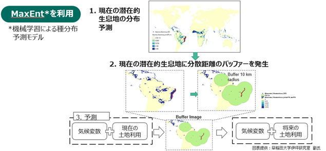
【図1】国立研究開発法人 森林研究・整備機構 森林総合研究所が開発したMaxEntモデルを利用した潜在的生息地域の予測
<関連情報>
将来の土地利用変化が生物多様性の絶滅率に及ぼす影響を評価するための、場所に基づく被害要因 Location-Based Damage Factors to Assess the Impact of Future Land-Use Changes on the Biodiversity Extinction Rate
Runya Liu,Haruka Ohashi,Akiko Hirata,Longlong Tang,Tetsuya Matsui,Kousuke Terasaki,and Norihiro Itsubo
Environmental Science & Technology Published: June 24, 2026
DOI:https://doi.org/10.1021/acs.est.6c02140
Abstract
Rising warnings of a potential sixth mass extinction and ecosystem degradation, fueled by climate change and human activities, highlight the need for an accurate measurement of human impacts on biodiversity loss to support effective policymaking. This study incorporates the extinction rate metric with the life-cycle impact assessment (LCIA) model to develop a set of policy-relevant, closed-loop spatiotemporal damage factors (DFs). Here, biodiversity damage is expressed in E/MSY (expected extinctions per million species years), representing extinction rate-based impacts and intrinsic biodiversity value. This approach enabled quantification of the biodiversity extinction rate due to future land use changes. The total net extinction rate was estimated at 161.9 E/MSY, and the global weighted average DF was estimated at 1.73 × 10–05 E/MSY/km2 as a species richness- and area-weighted summary of spatially heterogeneous damage. The grid-scaled DF results were provided at a global resolution of 0.25 arc-degrees. DFs indicated marginal extinctions from land use changes within each grid cell, providing a means to customize the disaggregated-scale DF for various LCA inventories. These results improve the interpretability of location-based biodiversity assessments, making them more relevant to policy decisions.