2026-11-11 中国科学院(CAS)
中国科学院合肥物質科学研究院の朱輝(ZHU Hui)教授らの研究グループは、ロボットによる周囲環境の認識精度を高めるため、3次元シーン再構築と自己位置推定・地図作成に関する2つの新手法を開発した。第1の「LR-SGS」は、LiDAR(レーザー画像検出・測距)とカメラ画像を組み合わせ、点群の反射強度情報を活用することで、夜間など照明条件が変化する環境でも高精度な3次元シーンを再構築する。Waymoなどのデータセットを用いた実験で、再構築精度と学習効率の向上を確認し、自動運転シミュレーション用の仮想環境生成にも対応する。第2の「MMD-SLAM」は、点・線・平面などの幾何学的特徴を統合し、ロボットの自己位置推定と3次元地図の整合性を改善する手法である。リアルタイム処理を維持しながら追跡・地図作成性能を向上させた。両研究はICRA 2026で発表採択され、LR-SGSは5,000件以上の投稿の中からロボット知覚分野の最優秀論文賞最終候補3件の一つに選ばれた。
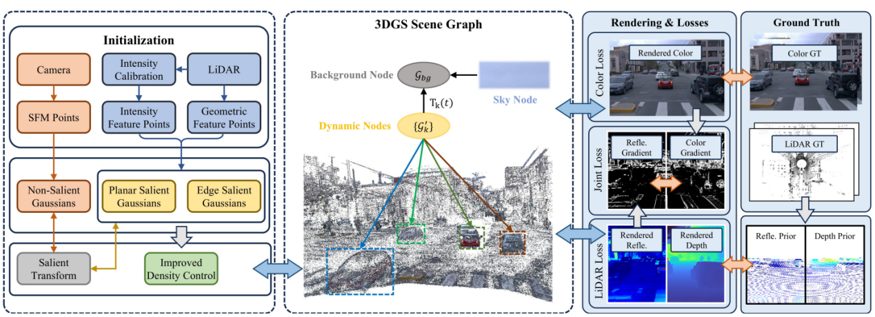
LR-SGS Architecture (Image by JIANG Chunmao)
<関連情報>
- https://english.cas.cn/newsroom/research-news/202611/t20261111_1213660.shtml
- https://ieeexplore.ieee.org/document/11696891
LR-SGS:自動運転シーン再構築のための、堅牢なLiDAR反射率誘導型顕著性ガウススプラッティング LR-SGS: Robust LiDAR-Reflectance-Guided Salient Gaussian Splatting for Self-Driving Scene Reconstruction
Ziyu Chen; Fan Zhu; Hui Zhu; Deyi Kong; Xinkai Kuang; Yujia Zhang;…
2026 IEEE International Conference on Robotics and Automation Date Added to IEEE Xplore: 30 September 2026
DOI:https://doi.org/10.1109/ICRA57385.2026.11696891
Tii-summary
自動運転システムの開発では、実際の走行環境を高精度な3次元デジタル空間に再構築し、危険事象の再現や学習用データの生成に活用する技術が重要である。本研究では、従来の3次元ガウシアンスプラッティング(3DGS)が、カメラ画像に依存するか、LiDARを初期化や深度情報の補助に限定して利用していた課題に着目し、LiDARの反射率情報とRGB画像を統合するLR-SGSを開発した。本手法では、LiDARから抽出した幾何学的特徴点と反射率特徴点を用いて、構造を意識したSalient Gaussian表現を初期化し、特徴変換と密度制御の改良によって、物体の境界や平面構造を効率的に再現する。さらに、LiDARの強度情報を反射率に較正し、照明条件に依存しにくい材料情報として各ガウシアンに付与することで、RGB画像との境界整合性を高めた。Waymo Open Datasetを用いた実験では、従来手法より少ないガウシアン数と短い学習時間で優れた再構築性能を達成し、特に複雑な照明環境ではOmniReを1.18 dBのPSNR上回った。本研究は、LiDARとカメラの相補的な情報を活用し、自動運転向け3次元環境再構築の精度と効率を改善する手法を示している。
High-fidelity 3D reconstruction of driving environments is essential for autonomous driving development, enabling the reproduction of critical safety scenarios and the generation of diverse training data. This study addresses limitations of conventional 3D Gaussian Splatting (3DGS), which typically relies primarily on camera images or uses LiDAR only for initialization or depth supervision. The authors propose LR-SGS, a robust LiDAR-reflectance-guided Salient Gaussian Splatting method that integrates LiDAR reflectance information with RGB imagery. The method initializes a structure-aware Salient Gaussian representation using geometric and reflectance feature points extracted from LiDAR, while improved salient transformation and density control enable more effective representation of object boundaries and planar structures. Furthermore, calibrated LiDAR intensity is incorporated into each Gaussian as a lighting-invariant material channel, improving boundary consistency through joint alignment with RGB information. Experiments on the Waymo Open Dataset demonstrate superior reconstruction performance with fewer Gaussians and shorter training times than existing approaches. In particular, LR-SGS outperforms OmniRe by 1.18 dB in peak signal-to-noise ratio (PSNR) under complex lighting conditions. These findings demonstrate the potential of integrating complementary LiDAR and camera information to improve the accuracy and efficiency of 3D scene reconstruction for autonomous driving applications.
High-fidelity 3D reconstruction of driving environments is essential for autonomous driving development, enabling the reproduction of critical safety scenarios and the generation of diverse training data. This study addresses limitations of conventional 3D Gaussian Splatting (3DGS), which typically relies primarily on camera images or uses LiDAR only for initialization or depth supervision. The authors propose LR-SGS, a robust LiDAR-reflectance-guided Salient Gaussian Splatting method that integrates LiDAR reflectance information with RGB imagery. The method initializes a structure-aware Salient Gaussian representation using geometric and reflectance feature points extracted from LiDAR, while improved salient transformation and density control enable more effective representation of object boundaries and planar structures. Furthermore, calibrated LiDAR intensity is incorporated into each Gaussian as a lighting-invariant material channel, improving boundary consistency through joint alignment with RGB information. Experiments on the Waymo Open Dataset demonstrate superior reconstruction performance with fewer Gaussians and shorter training times than existing approaches. In particular, LR-SGS outperforms OmniRe by 1.18 dB in peak signal-to-noise ratio (PSNR) under complex lighting conditions. These findings demonstrate the potential of integrating complementary LiDAR and camera information to improve the accuracy and efficiency of 3D scene reconstruction for autonomous driving applications.
出典:2026 IEEE International Conference on Robotics and Automation (ICRA)。IEEE Xplore掲載のAbstractおよび書誌情報に基づく要約。