2026-11-03 中国科学院(CAS)
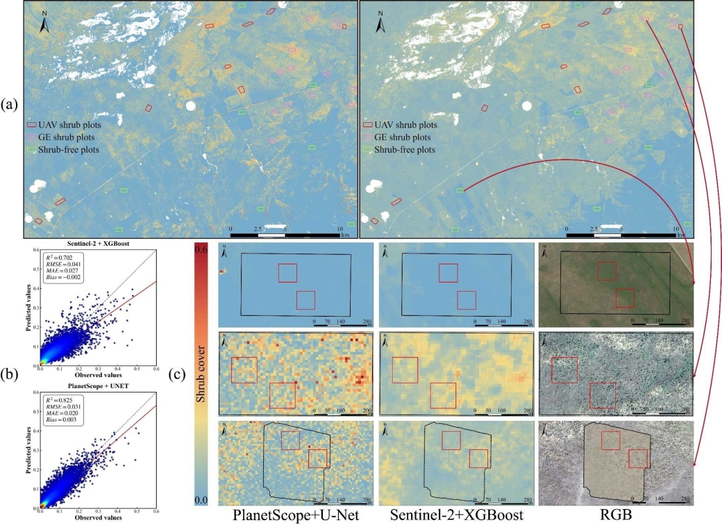
Shrub cover estimated from PlanetScope imagery using U-Net and from Sentinel-2 imagery using XGBoost. (Image by AIRCAS)
<関連情報>
- https://english.cas.cn/newsroom/research-news/202611/t20261103_1213111.shtml
- https://www.tandfonline.com/doi/full/10.1080/17538947.2026.2724759
PlanetScopeの時系列データと深層学習を統合した、半乾燥ステップにおける低木侵入のモニタリング Integrating PlanetScope time-series and deep learning for monitoring of shrub encroachment in semi-arid steppes
Chaochao Chen,Hengcong Yang,Gaoke Yueliang,Bingbing Wang & Xiaosong Li
International Journal of Digital Earth Published: 18 Sep 2026
DOI:https://doi.org/10.1080/17538947.2026.2724759
Abstract
Shrub encroachment threatens the functioning and livestock productivity of arid and semi-arid grasslands, yet accurate shrub-cover estimation remains difficult because shrub crowns are small, fragmented, and mixed with herbaceous vegetation and soil. We developed a fine-scale mapping framework combining 3-m PlanetScope time-series imagery with U-Net in Xilinhot, Inner Mongolia. Fifteen-day composites from May to October captured seasonal differences, while a composite loss function addressed sparse and imbalanced labels. On the within-plot test set, the model achieved R2 = 0.649, RMSE = 0.055, MAE = 0.036, and Bias = 0.003. Leave-one-plot-out validation yielded a mean R2 of 0.411 ± 0.188 across shrub-covered plots. Compared with a late-June single-period input, the full time series increased R2 by 16.73% and reduced high-cover underestimation and overprediction in shrub-free hay meadows. U-Net preserved more fine-scale spatial variation than conventional pixel-based models. At a common 10-m scale, PlanetScope/U-Net achieved R2 = 0.825 and RMSE = 0.031, versus 0.702 and 0.041 for Sentinel-2/XGBoost, reflecting both spatial resolution and modelling strategy. The framework shows promise for regional monitoring, although native-scale smoothing and limited independent validation remain important constraints.