2026-07-15 コペンハーゲン大学(UCPH)
<関連情報>
- https://news.ku.dk/all_news/2026/07/new-study-pinpoints-europes-most-critical-wetlands-for-climate-action/
- https://www.nature.com/articles/s41586-026-10760-9
高度に分断されたヨーロッパの湿地は、修復の必要性が不均一である Highly fragmented European wetlands with uneven restoration needs
Gyula Mate Kovács,Xiaoye Tong,Dimitri Gominski,Stefan Oehmcke,Stéphanie Horion,Christin Abel,Eva Ivits,Guy Schurgers,Bo Elberling,Alexander Prishchepov,Sebastian van der Linden,Susan Page,Alexandra Barthelmes,Franziska Tanneberger & Rasmus Fensholt
Nature Published:15 July 2026
DOI:https://doi.org/10.1038/s41586-026-10760-9
Abstract
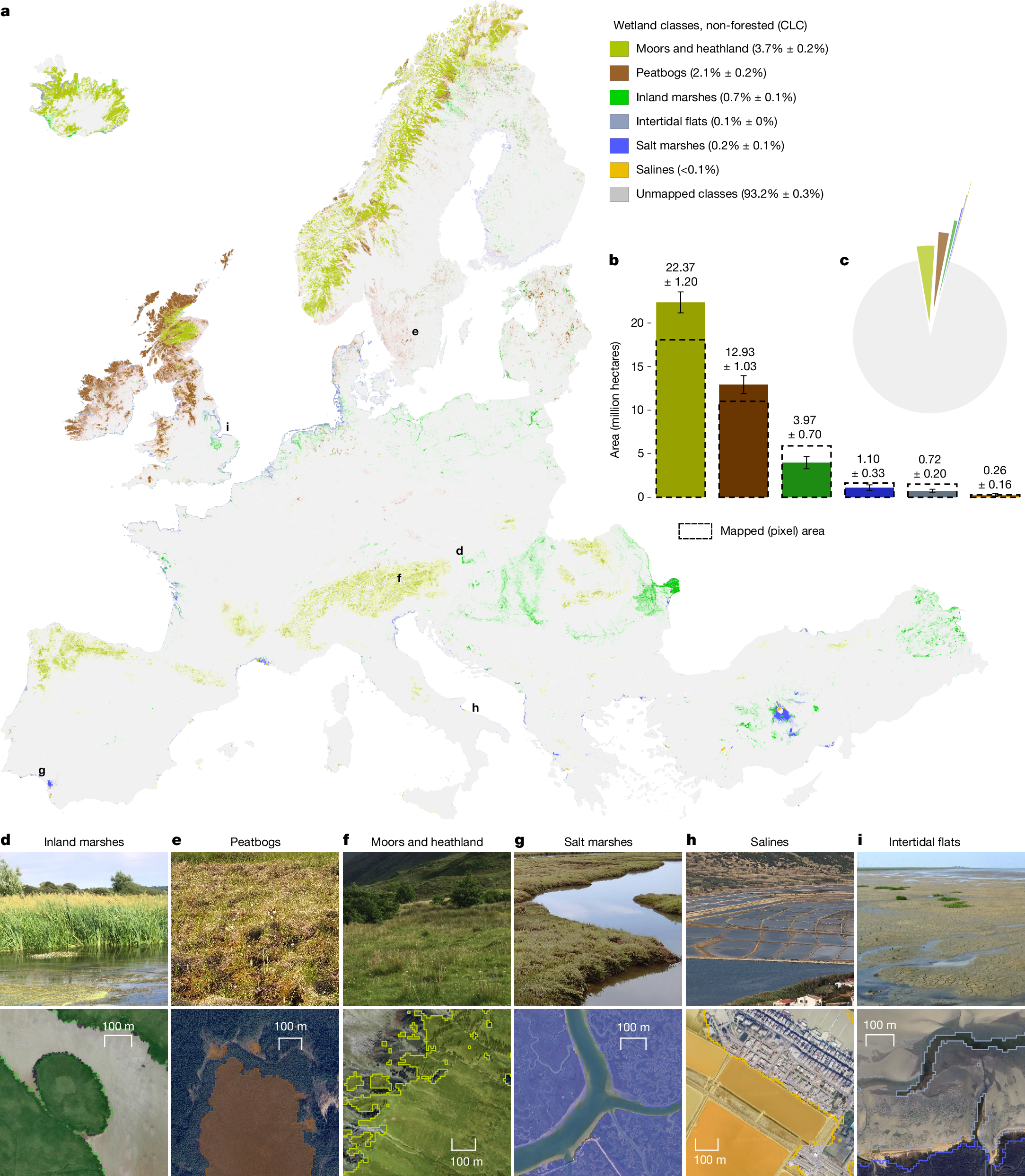
European wetlands store large carbon reserves1, but centuries of land use have eroded carbon stocks and biodiversity2. The European Union (EU) Nature Restoration Law (NRL)3 requires at least 30% of wetland ecosystems not in ‘good condition’ to be restored by 2030, yet spatially consistent information on wetland types and condition remains scarce. Using 10-m satellite imagery and machine learning, we map six seminatural open wetland types and land-use disturbance across 38 European countries. Wetlands are highly fragmented, with an estimated 27–33% of wetland area occurring in map-defined patches <25 ha and 7–11% in patches <1 ha, exposing many small sites missed by coarser products. We estimate that human activities affect 20.4 ± 3.4% of wetland areas (95% confidence interval), with inland wetland types most affected, and up to 5 Gt CO2-eq of soil carbon potentially lost relative to an undisturbed baseline. Translating disturbed area into NRL restoration targets, we find that several countries’ pledges are broadly consistent with our 2030 estimates, whereas others lack quantified commitments despite substantial candidate areas identified by our maps. The resulting standardized, high-resolution products provide an EU-wide baseline tailored to the NRL and a reproducible template for linking satellite mapping to restoration targets, supporting progress tracking.