2026-11-02 ハーバード大学
<関連情報>
- https://salatainstitute.harvard.edu/an-audit-from-orbit-satellites-help-countries-count-the-methane-they-miss/
- https://gmd.copernicus.org/articles/18/3311/2025/
統合メタン逆解析(IMI)2.0:TROPOMI衛星観測データを用いて、世界中のメタン総排出量を高解像度でモニタリングするための、改良された研究・関係者向けツール Integrated Methane Inversion (IMI) 2.0: an improved research and stakeholder tool for monitoring total methane emissions with high resolution worldwide using TROPOMI satellite observations
Lucas A. Estrada, Daniel J. Varon, Melissa Sulprizio, Hannah Nesser, Zichong Chen, Nicholas Balasus, Sarah E. Hancock, Megan He, James D. East, Todd A. Mooring, Alexander Oort Alonso, Joannes D. Maasakkers, Ilse Aben, Sabour Baray, Kevin W. Bowman, John R. Worden, Felipe J. Cardoso-Saldaña, Emily Reidy, and Daniel J. Jacob
Geoscientific Model Development Published:04 Jun 2025
DOI:https://doi.org/10.5194/gmd-18-3311-2025
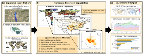
Figure 1Summary of major new features in IMI 2.0 divided into three categories: (a) expanded input options, (b) multiscale inversion capabilities, and (c) enriched output. Numbering of individual features corresponds to the relevant section in Sect. 3. The methane plume map in the top left panel is from Carbon Mapper (Methane Dashboard, Carbon Mapper Dashboard, 2024).
Abstract
Satellite observations of atmospheric methane are a powerful resource for quantifying methane emissions over any region worldwide. The inverse methods needed to infer emissions from these observations require a high level of scientific and technical expertise as well as access to large computational and data processing resources. The Integrated Methane Inversion (IMI) is an open-access cloud computing tool designed for researchers and non-expert users to obtain total sector-resolved methane emissions worldwide at up to 0.25°×0.3125° (≈25×25km-2) resolution by analytical inversion of TROPOMI satellite observations with closed-form error characterization. Here we describe IMI version 2.0 with vastly expanded capabilities relative to the original version. Major developments include (i) a new blended TROPOMI+GOSAT dataset for higher data quality, (ii) order-of-magnitude speed-up in Jacobian matrix construction, (iii) improved error characterization through use of super-observations, (iv) improved methods for initial and boundary conditions, (v) adaptive spatial resolution linked to observational information content, (vi) incorporation of point source observations in state vector construction, (vii) option to optimize tropospheric OH (main methane sink), (viii) global inversion capability, (ix) Kalman filter option for continuous monitoring of emissions, (x) updated default prior emission inventories, (xi) option for lognormal error probability density functions to characterize emissions, (xii) additional output visualization (sectoral emissions, temporal variability), and (xiii) containerization to facilitate download to local computing facilities and operation as part of the US GHG Center. A 2023 annual inversion with 28 d temporal resolution for the contiguous US (CONUS) is presented as a demonstration of IMI 2.0 capabilities.