2026-09-25 東北大学
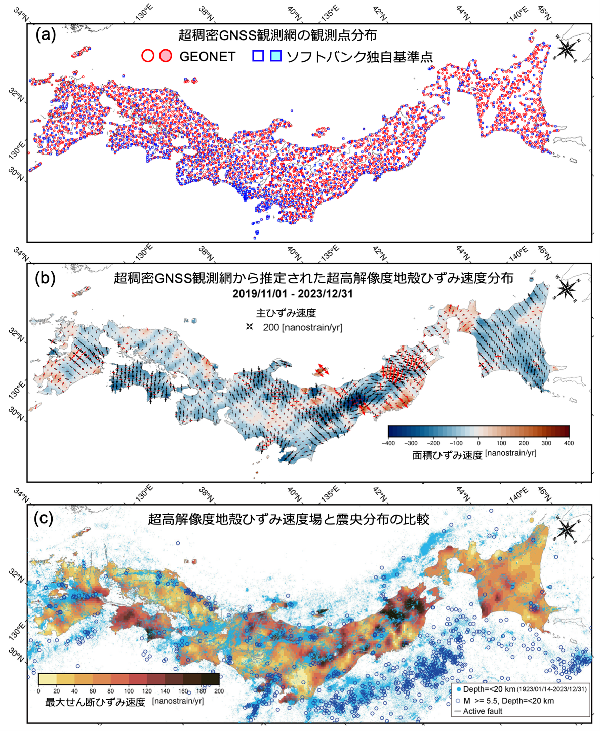
図1. (a)超稠密GNSS観測網の観測点分布。丸がGEONET、四角がソフトバンク独自基準点を示す。塗りつぶしたシンボルを地殻ひずみ速度場の推定に用いた。(b)超稠密GNSS観測網から推定された超高解像度地殻ひずみ速度分布。面積ひずみ速度と主ひずみ速度を示す。(c)超高解像度地殻ひずみ速度場(最大せん断ひずみ速度)と震央分布の比較。灰色の線が活断層、1923/01/14-2023/12/31の期間に発生した、水色の点が深さ20km以浅、青の丸が深さ20km以浅マグニチュード5.5以上の地震の震央分布を示す。
<関連情報>
- https://www.tohoku.ac.jp/japanese/2026/09/press20260925-03-integrated.html
- https://link.springer.com/article/10.1186/s40623-026-02475-y
官民統合GNSSステーションによる日本の高精度歪み速度マッピング Fine-scale strain-rate mapping of Japan from integrated public–private GNSS stations
Miku Ohtate, Yusaku Ohta, Mako Ohzono & Hiroaki Takahashi
Earth, Planets and Space Published:22 September 2026
DOI:https://doi.org/10.1186/s40623-026-02475-y
Abstract
We integrated observational data from the Global Navigation Satellite System (GNSS) Earth Observation NETwork System (GEONET) in Japan, operated by the Geospatial Information Authority of Japan, with over 3,300 proprietary reference stations operated by SoftBank Corp., and, using observations from November 2019 to December 2023, estimated a nationwide interseismic strain-rate field (with postseismic contributions in some regions). We adopted an established framework that fits locally linear horizontal-velocity models with roughness-controlled spatial regularization. The degree of spatial locality (i.e., the roughness control parameter) was optimized using an L-curve. After quality control, 3,606 stations remained. In the analysis that jointly used GEONET and SoftBank data, the mean (grid-averaged) locality scale, expressed by the distance-decay constant , was approximately 21 km (GEONET only: ~ 39 km; SoftBank only: ~ 25 km). We extracted the short-wavelength component as the residual of the original field after applying a 2D top-hat low-pass filter with a 50-km radius (the long-wavelength component). The maximum shear strain rate formed clustered patches within the Niigata–Kobe Tectonic Zone, while the short-wavelength maximum shear strain rate revealed a spatial correspondence between seismicity and the strain-rate field in northern Hokkaido and in the San-in Shear Zone, as well as a correspondence with the distribution of Quaternary and Active volcanoes along the Ou Backbone Range. Repeated random decimation tests (10% removal; n=100) indicated stable recovery of the principal features and quantified epistemic uncertainty. Rather than proposing a new estimator, our contribution lies in integrating public and private GNSS networks and validating their robustness, thereby refining Japan’s interseismic deformation patterns and strengthening the quantitative foundation for inland earthquake modeling.