
")
2026-04-08 バージニア工科大学(VirginiaTech)
<関連情報>
- https://news.vt.edu/articles/2026/04/science-sinking-java-island.html
- https://www.science.org/doi/10.1126/sciadv.aec0172
ジャワ島における地盤沈下とその相対的海面変動への影響 Land subsidence on Java Island and its contributions to relative sea level change
Leonard O. Ohenhen, Manoochehr Shirzaei, Praveen Kumar, Arif Aditiya, […] , and Philip S.J. Minderhoud
Science Advances Published:8 Apr 2026
DOI:https://doi.org/10.1126/sciadv.aec0172
Abstract
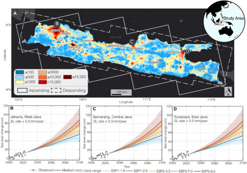
Rising sea levels and land subsidence combine to determine relative sea level (RSL) rise, which is intensifying coastal hazards. However, many densely populated regions lack the observational infrastructure to identify and quantify land subsidence contribution to RSL, hindering effective planning of responses. Here, we used satellite radar observations to generate a high-resolution assessment of land subsidence across Java Island, Indonesia, and evaluate its contribution to 21st-century RSL change. We identify widespread and temporally evolving subsidence with rates ranging from 1 to 15 cm/year in multiple coastal cities. Using machine learning spatiotemporal clustering and ancillary datasets, we attribute the dominant subsidence mechanisms to resource extraction across various geographic and geological settings. We further construct virtual tide gauges at 5-km intervals along the northern coastline, revealing that contemporary subsidence will dominate RSL budgets over the next 25 years along >75% of the coast. These findings underscore the urgent need to integrate subsidence into sea level risk and adaptation assessments in vulnerable coastal regions.
検出手法(Penguin toxicologists find forever chemicals in remote Patagonia)")
")