2022-10-27 ペンシルベニア州立大学(PennState)
研究チームは地形データを用いて、約35億年前の海岸線と、少なくとも900メートルの厚さの堆積物が、数十万平方キロメートルを覆っていた決定的な証拠を示すことができた。
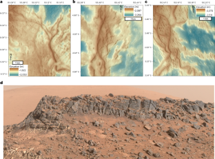
チームは、米国地質調査所が開発したソフトウェアを使用して、米国航空宇宙局(NASA)と火星オービターレーザー高度計のデータをマッピングした。その結果、6500キロメートル以上の河川尾根を発見し、それらを20のシステムに分類することで、尾根が古代の火星の海岸線の名残である浸食された河川デルタまたは海底チャネルベルトである可能性が高いことを明らかにした。
また、海嶺の厚さ、標高、位置、堆積物の流れ方向などの岩石の構成要素から、この地域の古地理がどのように変化してきたかを理解することができた。
Nature Geoscience誌に掲載された別の論文では、メキシコ湾の海底の地層を見るために使われる音響画像技術を、火星のような盆地の侵食のモデルに応用しています。研究者たちは、火星全体に広く見られるフルビアルリッジと呼ばれる地形は、エオリス・ドルサと同様の大きな盆地から浸食された古代の川の堆積物である可能性が高いと判断した。
<関連情報>
- https://www.psu.edu/news/research/story/traces-ancient-ocean-discovered-mars/
- https://agupubs.onlinelibrary.wiley.com/doi/abs/10.1029/2022JE007390
- https://www.nature.com/articles/s41561-022-01058-2
Aeolis Dorsaのデルタ堆積物に基づく火星海洋縁の古地理復元 Paleogeographic Reconstructions of an Ocean Margin on Mars Based on Deltaic Sedimentology at Aeolis Dorsa
Benjamin T. Cardenas,Michael P. Lamb
Journal of Geophysical Research: Planets Published: 12 October 2022
DOI:https://doi.org/10.1029/2022JE007390
Abstract
The evidence for an ancient ocean in Mars’ northern hemispheric basin during the Noachian/Hesperian is contentious. Much of the work is based on the modern topography by assuming that erosion has not significantly reshaped the Martian surface over the last 3.5 billion years, despite evidence to the contrary. Here, we provide new evidence for a northern ocean or large sea based on stratigraphic analysis of sedimentary basin fill exposed at Aeolis Dorsa. We mapped over 6,500 km of fluvial ridges, grouped them into 20 systems, and present evidence that they are the eroded remnants of river deltas or submarine-channel belts, together defining the stratigraphy of an ancient ocean margin. We used Context Camera stereo-pair elevation models to measure the stratigraphic positions of each system and used branching directions to determine paleoflow directions. By grouping landforms based on stratigraphic position and paleoflow directions, we reconstructed the paleogeography at Aeolis Dorsa over 5 timesteps; all cases differ from the modern topography. We tracked the initial regression and later transgression of a shoreline during at least 900 m of sea-level rise, a scale consistent with a northern ocean on a warm and wet early Mars.
Key Points
- Erosion at Aeolis Dorsa, Mars, has exposed a km-thick sedimentary accumulation interpreted to be marginal deposits of a large water body
- Paleoflow directions suggest an evolving paleo-shoreline geometry that does not conform to the modern topography
- Deposits record sea-level rise at a scale consistent with the northern ocean hypothesis
Plain Language Summary
A major question in Mars history is whether the planet had an ocean in its low-elevation northern hemisphere. Here, we show evidence that a substantial sedimentary accumulation, at least 900 m thick and covering hundreds of thousands of square km, developed at the margin of an ancient ocean. Aeolis Dorsa is the name of a trough-like region of Mars about 500 km wide and 900 km long, surrounded east and west by 2 km-high plains and to the south by steep slopes up to the southern hemisphere. There, we mapped over 6,500 km of exposed fluvial ridges, landforms that show the locations of ancient river channels. We organized the ridges into 20 branching systems. Measurements of ancient flow directions and stratigraphic positions record a history of an ocean-scale shoreline that, over time, rose at least 900 m vertically while retreating from north to south. The modern topography is defined by differential erosion into this stratigraphy and is different from the ancient geography. Sea-level rise is consistent with an extended warm and wet climate, not a mostly frozen early Mars.
古代の堆積盆地の盛り土に刻まれた河川尾根の火星景観 Martian landscapes of fluvial ridges carved from ancient sedimentary basin fill
Benjamin T. Cardenas,Michael P. Lamb & John P. Grotzinger
Nature Geoscience Published:27 October 2022
DOI:https://doi.org/10.1038/s41561-022-01058-2

Abstract
Large sedimentary basins contain archives of Earth history. It is unknown to what extent similar basins existed on Mars because there are few observations relating to the subsurface and it is difficult to identify buried deposits. Here, we used numerical simulations to show that landscapes of networks of topographic ridges that are abundant on the surface of Mars may represent erosional windows into thick, basin-filling river deposits that accumulated over long time spans. We used a numerical model to drive hillslope creep and differential erosion from the wind to simulate Mars-like exhumation processes acting on basin-filling fluvial strata, which we based on those buried in the Gulf of Mexico on Earth, as imaged using three-dimensional reflectance seismology. Simulations produced remarkably Martian landscapes in which the preferential erosion of mudstone relative to sandstone channel belts leads to the development of complex patterns of intersecting ridges. Our findings contrast to the existing view of ridged Martian landscapes as thin-skinned surface deposits preserving fluvial landscapes at a snapshot in time. Instead, the ridge cross-cutting patterns produced by the model reflect the exhumation of channel bodies at different stratigraphic levels, exposing basin strata accumulated over time scales of 500,000 years. Thus, we propose that fluvial ridges on Mars may expose an archive of long-lived aqueous processes.


