2026-09-30 合肥物質科学研究院(HFIPS)
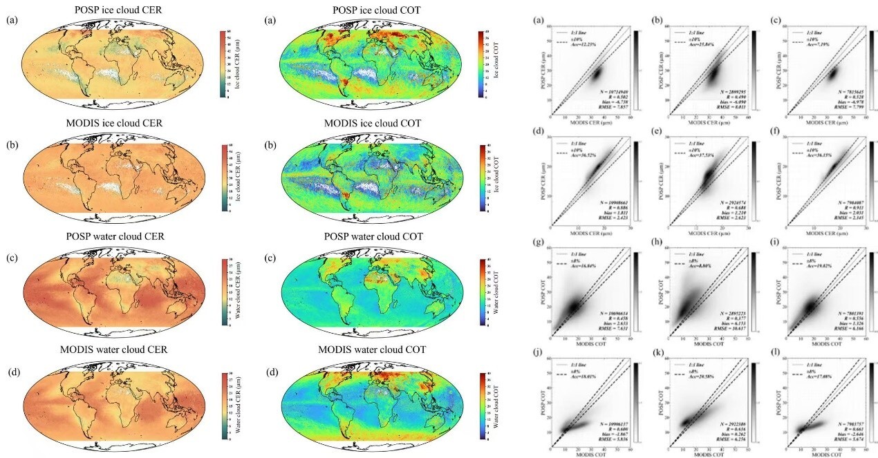
Global retrieval results and comparative validation of CER and COT from POSP/GF-5(02). (Image by YU Haixiao)
<関連情報>
- https://english.hf.cas.cn/nr/rn/202609/t20260930_1201615.html
- https://ieeexplore.ieee.org/document/11683645
- https://www.sciencedirect.com/science/article/abs/pii/S0022407326001329
GF-5(02) POSP観測データを用いた反射率補正と雲光学的厚さおよび有効半径の算出 Reflectance Correction and Retrieval of Cloud Optical Thickness and Effective Radius Using GF-5(02) POSP Observations
Yicheng Zhou; Haixiao Yu; Xuefeng Lei; Zhenhai Liu; Jiaming Sun; Zhihui Wang,…
IEEE Transactions on Geoscience and Remote Sensing Published:08 September 2026
DOI:https://doi.org/10.1109/TGRS.2026.3731766
Abstract
Clouds are essential components of the weather and climate system, influencing it by altering the radiation balance and participating in the hydrological cycle. Cloud optical thickness (COT) and cloud effective radius (CER) are critical parameters describing cloud optical and microphysical properties. This study investigates the reflectance characteristics of the particulate observing scanning polarimeter (POSP) onboard GaoFen-5(02) satellite [POSP/GF-5(02)] and proposes a reflectance correction method based on the unified linearized vector radiative transfer model (UNL-VRTM). Using the corrected reflectance, COT and CER are retrieved through an optimized dual-channel method (0.865– 2.25 μ m), with channel selection guided by sensitivity analysis. The retrieval results are further assessed with Moderate Resolution Imaging Spectroradiometer (MODIS) products. Results show that, under the current correction method, the original POSP reflectance used for the cloud target is underestimated by 15.61%, 51.59%, and 44.38% at 0.865, 1.61, and 2.25 μ m, respectively. Region case studies demonstrate that after reflectance correction, the fractions of retrievals within the predefined accuracy thresholds increase by an average of 61.83% for CER and 47.08% for COT. Further case analysis shows that retrieval accuracy varies with cloud field heterogeneity and surface complexity, with CER accuracy decreasing by 50.56% relative to a homogeneous cloud field and COT accuracy decreasing by 13.23% relative to dark ocean surfaces. These results indicate that the proposed reflectance correction framework substantially enhances the accuracy of cloud property retrievals from POSP observations, providing improved capability for cloud remote sensing and supporting further studies of weather and climate processes.
衛星多角度偏波測定を用いた雲粒サイズ分布のグローバル高空間分解能取得 Global high spatial-resolution retrieval of cloud droplet size distributions using satellite multi-angle polarimetric measurements
Haixiao Yu, Cheng Chen, Yicheng Zhou, Yujia Cao, Yan Wang, Zhihui Wang, Haofei Wang, Xiaobing Sun, Jinji Ma, Jin Hong, Zhengqiang Li
Journal of Quantitative Spectroscopy and Radiative Transfer Available online: 6 April 2026
DOI:https://doi.org/10.1016/j.jqsrt.2026.109938
Highlights
- A newly high spatial-resolution (~3.3 km) global retrieval technique for CDSD from satellite multi-angle polarimetry is developed.
- The angular sampling requirements for CDSD retrievals are quantified using primary rainbow, supernumerary rainbow and glory scattering angles observed by DPC/GF-5 (02).
- A dynamic pixel-aggregation strategy for CDSD retrievals is proposed based on radiative transfer simulation and information content analysis, enabling an optimal trade-off between success rate and retrieval accuracy.
Abstract
Cloud Droplet Size Distributions (CDSD) play a crucial role in cloud microphysics and cloud-radiation-precipitation interactions. Assuming a gamma distribution, CDSD can be parameterized by the Cloud Effective Radius (CER) and the Cloud Effective Variance (CEV), representing the characteristic droplet size and the width of the size distribution, respectively. Multi-Angular Polarimetric (MAP) measurements currently provide the richest information content for simultaneously retrieving both the CER (reff) and CEV (veff) of liquid clouds, provided that the multi-angle observations adequately sample the cloud-bow angular region. However, the strict requirements of MAP retrieval methods on the angular distribution sampling and cloud heterogeneity have hindered the realization of high spatial-resolution global CDSD retrievals. Consequently, to guarantee sufficient sampling of the rainbow angular domain, earlier MAP inversions have largely depended on aggressive spatial aggregation, such as the retrieval at ∼150 km spatial-resolution for POLDER. Here, we exploit MAP measurements from the Directional Polarization Camera (DPC) onboard GaoFen-5 (02) (GF-5 (02)) satellite to investigate the key factors that constrain CDSD retrievals. Leveraging pre-inversion MAP Information Content (IC) analysis and neighboring-pixel weighted contributions during inversion, we develop a dedicated high spatial-resolution CDSD retrieval method based on dynamic pixel-aggregation tailored to global DPC/GF-5 (02) observations. IC simulations indicate that CER retrieval is more robust than CEV. The resulting products are evaluated against MODIS reff product to quantify retrieval performance. Consistent with POLDER-based studies, our DPC reff retrievals of show a global mean bias of approximately 4.8 μm smaller relative to the MODIS product from dual-channel approach with fixed veff in January 2024. Notably, the CDSD retrieval resolution improves from ∼150 km for the POLDER-based product to 3.3 km for DPC, owing to both the higher native spatial resolution of DPC and the proposed dynamic pixel-aggregation approach. Furthermore, under sufficient rainbow-angle (135°-165°) coverage, successful retrievals over ocean and land require aggregation scales no larger than 3 × 3 native DPC pixels for 68.84% and 72.09% of pixels, respectively. This result suggests that the pixel-aggregation strategies commonly adopted in current MAP retrievals may be overly conservative. Overall, this method represents an important step toward stable, high spatial-resolution global CDSD products from satellite MAP measurements and provides valuable constraints for future cloud property retrievals and climate-related applications.