2024-01-30 パシフィック・ノースウェスト国立研究所(PNNL)

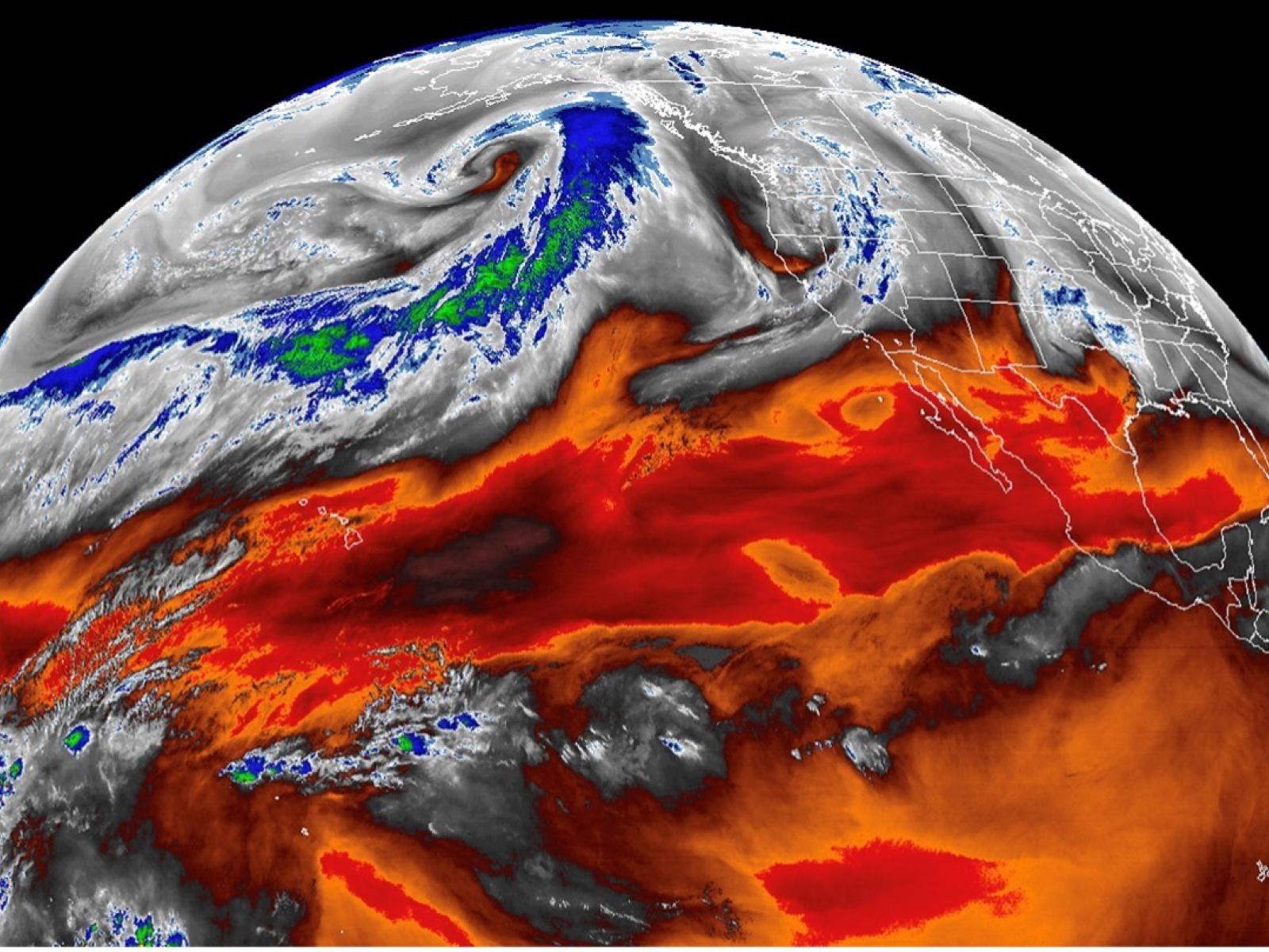
Atmospheric rivers, filaments of intense moisture transport in the atmosphere, can now be automatically detected in satellite observations. Image: NOAA
◆これにより、リアルタイムでARを観測し、再解析の限界を明らかにしました。新手法は湿気と風情報の統合により、AR幅などの改善が可能で、今後の気象モデルへの貢献が期待されます。
<関連情報>
- https://www.pnnl.gov/publications/detecting-atmospheric-rivers-satellite-observations
- https://agupubs.onlinelibrary.wiley.com/doi/10.1029/2023JD038937
衛星観測による大気河川とそれに伴う降水量の解析結果の評価 Evaluating the Representations of Atmospheric Rivers and Their Associated Precipitation in Reanalyses With Satellite Observations
Weiming Ma, Gang Chen, Bin Guan, Christine A. Shields, Baijun Tian, Emilio Yanez
Journal of Geophysical Research: Atmospheres Published: 20 November 2023
DOI:https://doi.org/10.1029/2023JD038937
Abstract
Atmospheric rivers (ARs) are filaments of enhanced horizontal moisture transport in the atmosphere. Due to their prominent role in the meridional moisture transport and regional weather extremes, ARs have been studied extensively in recent years. Yet, the representations of ARs and their associated precipitation on a global scale remains largely unknown. In this study, we developed an AR detection algorithm specifically for satellite observations using moisture and the geostrophic winds derived from 3D geopotential height field from the combined retrievals of the Atmospheric Infrared Sounder and the Advanced Microwave Sounding Unit on NASA Aqua satellite. This algorithm enables us to develop the first global AR catalog based solely on satellite observations. The satellite-based AR catalog is then combined with the satellite-based precipitation (Integrated Muti-SatellitE Retrievals for GPM) to evaluate the representations of ARs and AR-induced precipitation in reanalysis products. Our results show that the spreads in AR frequency and AR length distribution are generally small across data sets, while the spread in AR width is relatively larger. Reanalysis products are found to consistently underestimate both mean and extreme AR-related precipitation. However, all reanalyses tend to precipitate too often under AR conditions, especially over low latitude regions. This finding is consistent with the “drizzling” bias which has plagued generations of climate models. Overall, the findings of this study can help to improve the representations of ARs and associated precipitation in reanalyses and climate models.
Key Points
- Developed a novel method to detect atmospheric rivers (ARs) using moisture and wind data from satellite observations
- Reanalyses and satellite observations show high agreement with each other in AR frequency distributions
- Under AR conditions, reanalyses tend to precipitate too often and too lightly
Plain Language Summary
Atmospheric rivers (ARs) are filaments of enhanced horizontal moisture transport in the atmosphere. These weather systems are responsible for most of the poleward atmospheric moisture transport over midlatitudes and can cause extreme precipitation around the world. For a long time, researchers relied heavily on reanalysis products to study ARs. Albeit incorporating information from observations, reanalyses are produced by numerical models and thus should not be treated as real observations. In this study, for the first time, we developed a near global AR detection algorithm specially for satellite observations. Unlike previous AR detection algorithms designed for satellite observations, which were applicable to mean moisture content and on regional scales, our algorithm utilizes both the moisture field and wind information from satellite observations. Our algorithm can thus better characterize the transport nature of the detected ARs. Using both the developed algorithm and NASA satellite observations, we developed the first satellite-based near global AR catalog. This satellite-based AR catalog together with NASA satellite precipitation product was then used to evaluate how well major reanalyses represent ARs and their associated precipitation. We found that reanalyses generally perform well in representing the AR occurrence frequency and length, but show relatively larger uncertainty in representing the AR width. In reanalyses, ARs produce precipitation that is both too weak and too frequent. Our findings can help to improve the representation of ARs and associated precipitation in reanalyses and climate models. As the quality of satellite observations continues to improve, the methodology presented here can be applied to other satellite observations to develop higher resolution or higher frequency AR statistics.


