")
ブラウン大学の研究者たちの研究によると、アラスカのデナリ断層を横切る地殻プレートの厚さの変化が、断層が存在する場所に影響を与えていることがわかり、大きな断層や地震がどのように発生するのかに光を当てています。 A study by Brown researchers finds that changes in tectonic plate thickness across the Denali Fault in Alaska impacts where it is located, shedding light on how major faults and earthquakes occur.
2023-01-18 ブラウン大学
・今回の発見は、地質学的な断層が深化していく過程でどのように振る舞い、どのように現れるかについての理解における大きなギャップを埋め始めたものであり、将来的には、地震が頻繁に起こる地域である横ずれ断層の地震モデルをより良く開発するための研究へとつながる可能性があります。
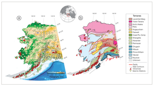
・この研究は12月にGeophysical Research Letters誌に掲載され、ブラウン大学の卒業生であるイザベラ・ガマが主導しました。この論文は主に、アラスカ州の大部分とカナダ西部の一部を横切る全長1,200マイルの断層、デナリ断層に焦点をあてています。2002年にはマグニチュード7.9の地震が発生し、シアトル、テキサス、ニューオーリンズなど遠くの湖を水浸しにした。
・研究者たちは、最先端の地震観測所ネットワークから得られた新しいデータを使って、アラスカ全域の地震波速度の新しい3Dモデルを作成しました。この革新的なツールにより、研究者はアラスカが乗っている構造プレートの厚さと内部強度の変化を発見しました。このモデルは、約80キロメートルもの深さに及ぶプレートの強度の変化が、デナリ断層がどこで生成されるかというメカニズムにどのようにフィードバックされるかを示しています。
・デナリ断層の南側では地殻が厚く、断層の北側では地殻が薄くなっていることは、これまでにも知られていた。しかし、プレートの深部にあるマントル部分の変化については、これまであまり明らかにされていなかった。
・今回の研究で、研究者らは、デナリ断層が、断層の北側で強度が増し、上部プレートを貫通して形成されていることを、初めて明らかにした。
・研究者たちは、プレートの底面や岩石層を見ると、断層の北側では岩石層がより強く厚く、南側ではより薄く弱いことを発見した。北側のプレートの深い部分は、ほとんど背骨のような役割を果たすと、彼らは論文で述べている。彼らは、地表の断層はこの厚くて強いリソスフェアの端に形成され、そこに留まったと結論付けている。
<関連情報>
- https://www.brown.edu/news/2023-01-18/denali-fault
- https://agupubs.onlinelibrary.wiley.com/doi/10.1029/2022GL101256
デナリ断層とアラスカ北部の岩石層厚の変化 Variations in Lithospheric Thickness Across the Denali Fault and in Northern Alaska
Isabella Gama, Karen M. Fischer, Colleen A. Dalton, Zachary Eilon
Geophysical Research Letters Published: 16 December 2022
DOI:https://doi.org/10.1029/2022GL101256
Abstract
While variations in crustal structure beneath the Denali fault in Alaska are well-documented, the existence of fault-correlated structures throughout the entire thickness of the continental lithosphere is not. A new model of shear-wave velocity structure obtained through joint inversion of surface wave and converted body wave data shows a northward increase in lithospheric thickness and velocity occurring across the Denali fault system. In northern Alaska, a dramatic increase in lithospheric thickness at the southern margin of the Arctic-Alaska terrane lies in the vicinity of the Kobuk fault system. These correlations support the view that transpressive deformation tends to localize at the margins of thicker, higher-strength lithosphere.
Key Points
- A new model of seismic shear-wave velocity beneath Alaska was obtained by jointly inverting surface wave and Sp body wave data
- The Denali fault lies just south of the margin of thicker and higher velocity upper plate lithosphere, as does the Kobuk fault
- These results support the view that gradients in lithospheric strength can be key to the localization of major continental strike-slip faults
Plain Language Summary
Major faults in Earth’s tectonic plates, such as Alaska’s Denali fault, begin as brittle fractures of the shallow crust and progress to include ductile shearing of the deeper crust. Changes in tectonic plate thickness or internal temperature have been observed beneath some faults, consistent with feedback between the strength of the deeper plate and the location of the fault. Using global earthquake signals, we built a new 3-D model of seismic velocity structure throughout Alaska, extending from the surface to hundreds of kilometers in depth. According to the model, the Denali fault coincides with a northward thickening and an apparent abrupt temperature increase within Alaska’s plate. Further north, at another boundary between geological provinces near the Kobuk fault, we also find an abrupt thickening of the plate. These relationships are consistent with faults being located near the edges of thicker, stronger regions of the tectonic plates.
")
")