
2026-04-27 中国科学院(CAS)
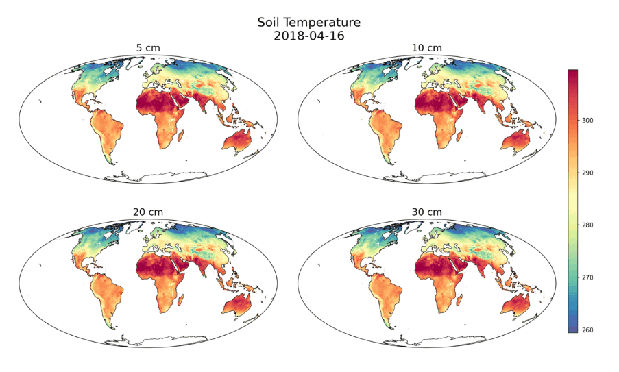
Global soil temperature profiles across diurnal cycles retrieved from FY-3/MWRI passive microwave and MODIS thermal infrared data. (Image by AIR)
<関連情報>
- https://english.cas.cn/newsroom/research-news/202605/t20260511_1159126.shtml
- https://www.sciencedirect.com/science/article/abs/pii/S092427162600184X
マイクロ波および熱赤外線観測の日周サイクルを統合した、地中温度プロファイルの初のマッピング First mapping of subsurface soil temperature profiles by integrating diurnal cycles of microwave and thermal infrared observations
Dabiao Chen, Huazhu Xue, Tianjie Zhao, Yuyang Xiong, Ning Li, Jingyao Zheng, Yipeng Cao, Yu Bai, Songbo Qu, Ling Yao, Tang Liu, Chi Wang, Haojie Zhang, Pei Yu, Lu Hu, Letu Husi, Li Jia, Jiancheng Shi
ISPRS Journal of Photogrammetry and Remote Sensing Available online: 7 April 2026
DOI:https://doi.org/10.1016/j.isprsjprs.2026.04.012
Abstract
Soil temperature (ST) is a fundamental meteorological variable that governs energy, water, and carbon exchanges across the land–atmosphere interface, with profound implications for hydrological forecasting, ecological modeling, and climate change projections. Despite its critical importance, global subsurface soil temperature profiles remain poorly characterized by existing remote sensing capabilities, which are limited to instantaneous, single-depth retrievals with inadequate temporal sampling. This study proposes a Diurnal Soil Thermal (DST) model founded on the one-dimensional heat conduction equation, representing daytime temperature propagation as a harmonic wave and nighttime cooling as an exponential decay. Building upon this physical model, we propose the Diurnal Soil Thermal–Mapping Algorithm for Profiles (DST-MAP), which integrates land surface temperature observations from Fengyun-3 multi-frequency microwave radiometer and MODIS thermal infrared sensors to retrieve diurnal temperature cycle parameters. The damping depth characterizing vertical attenuation is constrained by soil texture and satellite-derived soil moisture using a physically based parameterization. DST-MAP generates continuous hourly soil temperature estimates at 5, 10, 20, and 30 cm depths. Validation against in situ measurements from 450 + stations demonstrate robust performance, with correlation coefficients exceeding 0.87 and root-mean-square errors (RMSE) of 3.5–4.5 K across all depths. Accuracy is highest in shallow layers, progressively attenuating with depth yet remaining reliable even at 30 cm. Triple Collocation Analysis (TCA) among DST-MAP, MERRA-2, and GLDAS indicates theoretical uncertainties below 4 K for most land areas, with DST-MAP exhibiting superior consistency in arid regions compared to MERRA-2 and comparable performance to GLDAS. This work establishes an observation-driven, physically grounded framework for hourly-resolved subsurface temperature profiling that captures the complete diurnal thermal evolution, providing essential support for the development of next-generation land surface hydrothermal coupling models and satellite payloads.
")
")