地球モデルコラムコラボラトリーは、複雑なデータと気象観測を組み合わせて、高精度の気候モデルと予測を作成するオープンソースの研究プラットフォームです。 The Earth Model Column Collaboratory is an open-source research platform that pairs complex data with weather observations to create highly accurate climate models and forecast predictions.
2022-10-12 アルゴンヌ国立研究所(ANL)
EMC2がさらに便利なのは、これらのツールをすべて1つのソフトウェアパッケージに統合している点です。オープンソースソフトウェアとして設計されているため、研究者や一般市民が簡単にモデルや観測データを追加、使用、修正することができます。
アルゴンヌの研究者たちは、NASAのために開発されたアプローチを使って、DOEのエネルギーエクサスケール地球システムモデル(E3SM)と共同でEMC2を使用することを計画しています。
EMC2は、DOEの大気放射測定(ARM)プログラムの1つである気象観測を利用して、E3SMにおける雷雨の表現を改善することにより、気候科学者が降雨予測の不確実性を低減するのを支援する予定です。
つまり、アルゴンヌの研究者は、ペンシルバニア州立大学およびNASAと共同で、気候・気象モデルと気象観測機器からの観測値との比較を容易にするためにEMC2を開発したのです。EMC2は、気候モデル研究者と観測研究者のコラボレーションに共通のポイントを提供する。
<関連情報>
- https://www.anl.gov/article/new-tool-helps-researchers-investigate-clouds-rain-and-climate-change
- https://gmd.copernicus.org/articles/15/901/2022/
Earth Model Column Collaboratory (EMC2) v1.1: オープンソースによる大規模モデル用の地上ライダーおよびレーダー機器シミュレータとサブカラム生成ツール。 The Earth Model Column Collaboratory (EMC2) v1.1: an open-source ground-based lidar and radar instrument simulator and subcolumn generator for large-scale models
Israel Silber, Robert C. Jackson, Ann M. Fridlind, Andrew S. Ackerman, Scott Collis, Johannes Verlinde, and Jiachen Ding
Geoscientific Model Development Published: 01 Feb 2022
DOI:https://doi.org/10.5194/gmd-15-901-2022

Abstract
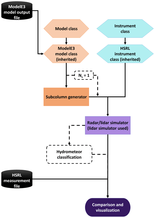
Climate models are essential for our comprehensive understanding of Earth’s atmosphere and can provide critical insights on future changes decades ahead. Because of these critical roles, today’s climate models are continuously being developed and evaluated using constraining observations and measurements obtained by satellites, airborne, and ground-based instruments. Instrument simulators can provide a bridge between the measured or retrieved quantities and their sampling in models and field observations while considering instrument sensitivity limitations. Here we present the Earth Model Column Collaboratory (EMC2), an open-source ground-based lidar and radar instrument simulator and subcolumn generator, specifically designed for large-scale models, in particular climate models, but also applicable to high-resolution model output. EMC2 provides a flexible framework enabling direct comparison of model output with ground-based observations, including generation of subcolumns that may statistically represent finer model spatial resolutions. In addition, EMC2 emulates ground-based (and air- or space-borne) measurements while remaining faithful to large-scale models’ physical assumptions implemented in their cloud or radiation schemes. The simulator uses either single particle or bulk particle size distribution lookup tables, depending on the selected scheme approach, to perform the forward calculations. To facilitate model evaluation, EMC2 also includes three hydrometeor classification methods, namely, radar- and sounding-based cloud and precipitation detection and classification, lidar-based phase classification, and a Cloud Feedback Model Intercomparison Project Observational Simulator Package (COSP) lidar simulator emulator. The software is written in Python, is easy to use, and can be straightforwardly customized for different models, radars, and lidars.
Following the description of the logic, functionality, features, and software structure of EMC2, we present a case study of highly supercooled mixed-phase cloud based on measurements from the U.S. Department of Energy Atmospheric Radiation Measurement (ARM) West Antarctic Radiation Experiment (AWARE). We compare observations with the application of EMC2 to outputs from four configurations of the NASA Goddard Institute for Space Studies (GISS) climate model (ModelE3) in single-column model (SCM) mode and from a large-eddy simulation (LES) model. We show that two of the four ModelE3 configurations can form and maintain highly supercooled precipitating cloud for several hours, consistent with observations and LES. While our focus is on one of these ModelE3 configurations, which performed slightly better in this case study, both of these configurations and the LES results post-processed with EMC2 generally provide reasonable agreement with observed lidar and radar variables. As briefly demonstrated here, EMC2 can provide a lightweight and flexible framework for comparing the results of both large-scale and high-resolution models directly with observations, with relatively little overhead and multiple options for achieving consistency with model microphysical or radiation scheme physics.


