2024-06-07 テキサス A&M大学
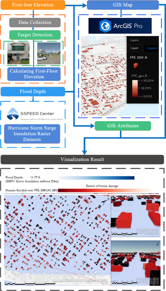
◆テキサスA&M大学の研究者たちは、3D可視化技術を使用してハリケーンの洪水の影響を事前に予測し、被害を軽減する方法を研究しています。これにより、洪水の影響を視覚的に確認でき、具体的な建物や道路の被害を予測できます。研究では、提案された防護堤「Ike Dike」の効果も評価され、リアルタイムの天気予報を基にしたモデルが安全性とコスト削減に貢献する可能性があります。この技術は、保険や予防インフラの投資判断に役立ち、地域社会の意識向上にも寄与します。
<関連情報>
- https://today.tamu.edu/2024/06/07/researchers-use-3d-visualization-to-predict-prevent-hurricane-damage/
- https://link.springer.com/article/10.1007/s44212-024-00043-x
ハリケーンの高潮が都市インフラに与える影響を3Dで可視化 3D visualization of hurricane storm surge impact on urban infrastructure
Xinyue Ye,Shoujia Li,Ge Gao,David Retchless,Zhenhang Cai,Galen Newman,Jiaxin Du & Nick Duffield
Urban Informatics Published:08 May 2024
DOI:https://doi.org/10.1007/s44212-024-00043-x

Abstract
As climate change intensifies, resulting in more severe rainfall events, coastal cities globally are witnessing significant life and property losses. A growingly crucial component for flood prevention and relief are urban storm flood simulations, which aid in informed decision-making for emergency management. The vastness of data and the intricacies of 3D computations can make visualizing the urban flood effects on infrastructure daunting. This study offers a 3D visualization of the repercussions of hurricane storm surge flooding on Galveston, TX residences, illustrating the impact on each structure and road across varied storm conditions. We employ target detection to pinpoint house door locations, using door inundation as a metric to gauge potential flood damage. Within a GIS-based framework, we model the damage scope for residences exposed to varying storm intensities. Our research achieves three core goals: 1) Estimating the storm inundation levels on homes across different storm conditions; 2) Assessing first-floor elevations to categorize housing damages into three distinct groups; and 3) Through visualization, showcasing the efficacy of a proposed dike designed to shield Galveston Island from future storm surge and flood events.


