2026-09-09 中国科学院(CAS)
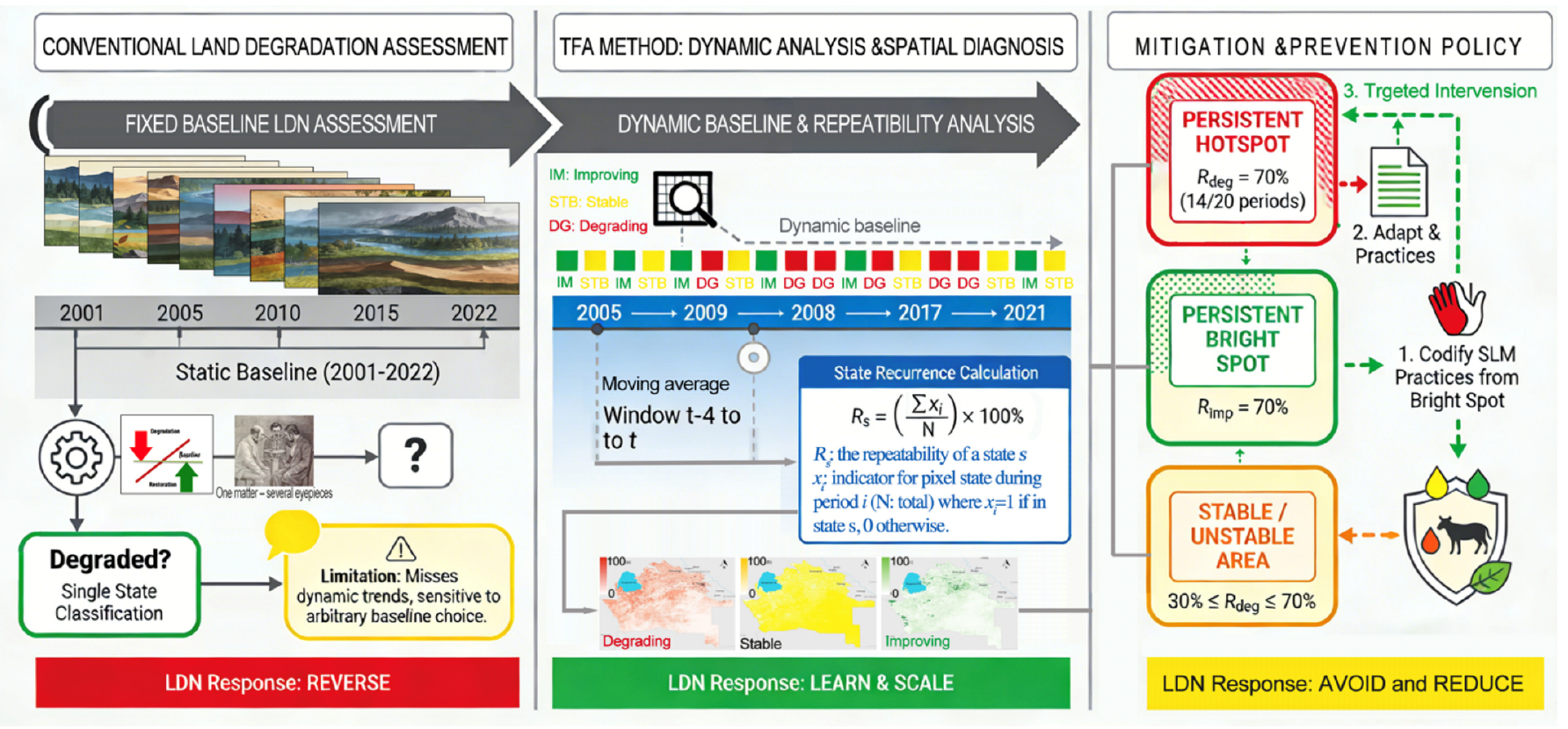
Conceptual framework of the Temporal Frequency Analysis (TFA) method. (Image by XIEG)
<関連情報>
- https://english.cas.cn/newsroom/research-news/202609/t20260910_1197720.shtml
- https://www.sciencedirect.com/science/article/pii/S0341816226007095
時間的頻度分析により、土地劣化のホットスポットと持続可能な利用の明るいスポットが特定される Temporal frequency analysis identifies land degradation hotspots and sustainable use bright spots
Anwar Eziz, German Kust, Olga Andreeva, Vladimir Podlesnov, Osman Ilniyaz, Hongjing Ren, Arken Tursun, Toqeer Ahmed, Mingyuan Du, Jiahe Song, Jiaqiang Lei, Alishir Kurban, Hossein Azadi
CATENA Available online: 25 August 2026
DOI:https://doi.org/10.1016/j.catena.2026.110499
Highlights
- Temporal Frequency Analysis (TFA) quantifies persistence of land degradation trends.
- Persistent degradation hotspots occupy <1% of dryland landscapes.
- TFA reveals bright spots of sustainable land use practices as models for scaling.
- Repeatability metrics link global LDN reporting to local landscape processes.
Abstract
Achieving Land Degradation Neutrality (LDN) requires tools that identify persistent degradation hotspots for targeted action, moving beyond static monitoring. We present a novel Temporal Frequency Analysis (TFA) that quantifies the repeatability of degradation or improvement trends as a measure of landscape process persistence. It analyzes changes in the land productivity dynamics indicator—the most responsive SDG 15.3.1 component in drylands—across five consecutive five-year periods from 2001 to 2022, using a moving average and a dynamic baseline. This dynamic baseline serves as an analytical reference for temporal diagnostics, complementing rather than replacing the fixed historical baseline used for standardized national reporting. Applied to Turkmenistan’s Dashoguz and Lebap provinces, TFA filters climatic noise to reveal spatially explicit, persistent degradation hotspots and improvement bright spots. We found that only a small fraction of the landscape (<1%) exhibits high repeatability of positive or negative trends, indicating that entrenched landscape degradation is hyper-localized. The analysis further reveals how soil-vegetation feedbacks and land-use practices interact to produce contrasting degradation trajectories across different landscape units—from irrigated croplands to desert pastures. The proposed TFA framework is scalable, offering a robust diagnostic tool that links global LDN reporting to local landscape process understanding. Beyond reporting, the framework directly informs the LDN response hierarchy by identifying where to avoid, reduce, or reverse degradation, thereby guiding integrated land-use planning and the LDN accounting mechanism. This provides actionable insights for adaptive land management in dryland regions worldwide. By distinguishing recurrent degradation from temporary variability, TFA strengthens the evidence base for applying the LDN response hierarchy, prioritizing restoration and sustainable land management, and accounting for losses and gains within integrated land-use planning.