2022-12-12 スイス連邦工科大学ローザンヌ校(EPFL)
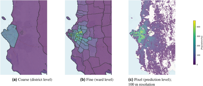
ICRCが活動するほとんどの国では、危機や紛争への対応であれ、復興支援であれ、最新の国勢調査データは入手できない。また、国勢調査の集計が行われても、急激な人口増加や人口動態の変化により、すぐに古くなってしまうことが多い。しかし、水道の復旧、食料の配給、予防プログラムの実行可能性の評価など、人道支援活動を行う際に、ある地域にどれだけの人がいるかを知っていれば、より効率的に作業を行うことができます。そこで、EPFLとチューリッヒ工科大学のエンジニアは、ICRCと協力して、人工知能ベースのプログラム「Pomelo」を開発しました。このソフトは、リモートセンシングシステムから得た大量の公共データ(建物の数、建物の平均サイズ、道路の近さ、道路地図、夜間照明など)をコンパイルし、ニューラルネットワークが学習した重み付けに基づいて集計するものである。Pomeloはアフリカの数カ国でテストされ、1ヘクタールという小さな面積で非常にきめ細かい結果を出すことができました。この研究成果は、Scientific Reportsに掲載されています。
・タンザニア、ザンビア、モザンビークで実証実験を実施
例えば、ある建物の公開データをもとに、その用途に応じた人口を論理的に推定することができる。「例えば、都市部では郊外よりも建物の高さが高くなる傾向がありますし、夜間照明が多い地域にはより多くの人が住む傾向があります」とトゥイアは言う。「これらの情報は、人口密度をより正確に推定するのに役立ちます。最初はソーシャルメディアのデータを使うことも考えましたが、危機的な状況、特に農村部では、こうしたアプリは十分に使われていないことに気づきました」。
エンジニアたちは、タンザニア、ザンビア、モザンビークなど、ICRCも活動しているアフリカのいくつかの国のデータを使って、プログラムをテストしました。ポメロを使用して、1ヘクタールあたりの人口密度を示す一連のデジタル地図を作成し、その結果を他のプログラムによる推定値と比較したのです。Pomeloは、ヘクタール単位だけでなく、低人口密度(1,000~2,000人)を含む、より大規模で粗いスケールでも、他のプログラムより正確であることが証明されました。
<関連情報>
- https://actu.epfl.ch/news/ai-enables-more-effective-humanitarian-action/
- https://www.nature.com/articles/s41598-022-24495-w
粗い国勢調査とオープンなジオデータから、きめ細かな人口マップを作成 Fine-grained population mapping from coarse census counts and open geodata
Nando Metzger,John E. Vargas-Muñoz,Rodrigo C. Daudt,Benjamin Kellenberger,Thao Ton-That Whelan,Ferda Ofli,Muhammad Imran,Konrad Schindler & Devis Tuia
Scientific Reports Published:22 November 2022
DOI:https://doi.org/10.1038/s41598-022-24495-w

Abstract
Fine-grained population maps are needed in several domains, like urban planning, environmental monitoring, public health, and humanitarian operations. Unfortunately, in many countries only aggregate census counts over large spatial units are collected, moreover, these are not always up-to-date. We present POMELO, a deep learning model that employs coarse census counts and open geodata to estimate fine-grained population maps with 100m ground sampling distance. Moreover, the model can also estimate population numbers when no census counts at all are available, by generalizing across countries. In a series of experiments for several countries in sub-Saharan Africa, the maps produced with POMELO are in good agreement with the most detailed available reference counts: disaggregation of coarse census counts reaches R2R2 values of 85–89%; unconstrained prediction in the absence of any counts reaches 48–69%.


