2025-03-21 中国科学院(CAS)
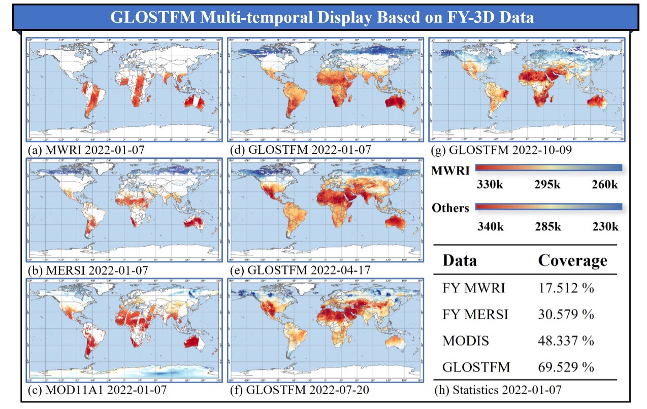
 GLOSTFM multi-temporal display based on FY-3D data. (Image by AIR)
<関連情報>
- https://english.cas.cn/newsroom/research_news/infotech/202503/t20250321_908496.shtml
- https://www.sciencedirect.com/science/article/abs/pii/S0034425725000446
GLOSTFM:地表面温度の解像度を向上させるためのマルチソース衛星観測を統合した全球時空間融合モデル GLOSTFM: A global spatiotemporal fusion model integrating multi-source satellite observations to enhance land surface temperature resolution
Qingyan Meng, Shize Chen, Linlin Zhang, Xiaolin Zhu, Yeping Zhang, Peter M. Atkinson
Remote Sensing of Environment Available online: 9 February 2025
DOI:https://doi.org/10.1016/j.rse.2025.114640
Highlights
- GLOSTFM is the first model used for global scale LST spatiotemporal fusion.
- GLOSTFM outperforms five methods in spatial details and time consumption.
- GLOSTFM considers Chinese Fengyun satellite microwave and infrared data.
- GLOSTFM can support high-frequency thermal monitoring applications.
Abstract
Land surface temperature (LST) data are crucial for global climate change research. While remote sensing data serve as a key source for LST, single-source sensor data often lack spatiotemporal continuity due to long satellite revisit intervals and cloud cover. Spatiotemporal fusion, which combines the strengths of multiple sources, can increase the available information. However, most current spatiotemporal fusion methods are designed for local-scale applications. This research proposes the Global Spatiotemporal Fusion Model (GLOSTFM) to generate global LST products. GLOSTFM, built on image pyramid principles, addresses the computational and complexity challenges of global-scale spatiotemporal fusion. Moreover, the model utilizes data from the novel Fengyun-3D satellite, which has a daily revisit capability and provides LST products separately derived from its thermal infrared (MERSI, 1 km) and microwave (MWRI, 25 km) sensors. By leveraging the cloud-penetrating capabilities of the microwave data to compensate for missing information, GLOSTFM increases the available information and reduces observational uncertainties. The results showcase high processing efficiency and enhanced spatiotemporal continuity, with an average RMSE of 2.874 K and an excellent R2 of 0.980. The utility of the GLOSTFM model for monitoring urban heat island effects in Beijing was explored to illustrate one application among a broad range of potential applications of the proposed GLOSTFM that require global data on LST across the Earth’s surface.


