
2024-08-12 カリフォルニア大学バークレー校(UCB)
<関連情報>
- https://news.berkeley.edu/2024/08/12/scientists-find-oceans-of-water-on-mars-its-just-too-deep-to-tap/
- https://www.pnas.org/doi/10.1073/pnas.2409983121
- https://www.nature.com/articles/nature26144
火星の地殻中層に存在する液体の水 Liquid water in the Martian mid-crust
Vashan Wright, Matthias Morzfeld, and Michael Manga
Proceedings of the National Academy of Sciences Published:August 12, 2024
DOI:https://doi.org/10.1073/pnas.2409983121
")
Abstract
Large volumes of liquid water transiently existed on the surface of Mars more than 3 billion years ago. Much of this water is hypothesized to have been sequestered in the subsurface or lost to space. We use rock physics models and Bayesian inversion to identify combinations of lithology, liquid water saturation, porosity, and pore shape consistent with the constrained mid-crust (∼11.5 to 20 km depths) seismic velocities and gravity near the InSight lander. A mid-crust composed of fractured igneous rocks saturated with liquid water best explains the existing data. Our results have implications for understanding Mars’ water cycle, determining the fates of past surface water, searching for past or extant life, and assessing in situ resource utilization for future missions.
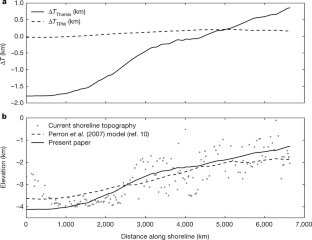
海岸線の変形から火星に海ができるタイミングを探る Timing of oceans on Mars from shoreline deformation
Robert I. Citron,Michael Manga & Douglas J. Hemingway
Nature Published:19 March 2018
DOI:https://doi.org/10.1038/nature26144
Abstract
Widespread evidence points to the existence of an ancient Martian ocean1,2,3,4,5,6,7,8. Most compelling are the putative ancient shorelines in the northern plains2,7. However, these shorelines fail to follow an equipotential surface, and this has been used to challenge the notion that they formed via an early ocean9 and hence to question the existence of such an ocean. The shorelines’ deviation from a constant elevation can be explained by true polar wander occurring after the formation of Tharsis10, a volcanic province that dominates the gravity and topography of Mars. However, surface loading from the oceans can drive polar wander only if Tharsis formed far from the equator10, and most evidence indicates that Tharsis formed near the equator11,12,13,14,15, meaning that there is no current explanation for the shorelines’ deviation from an equipotential that is consistent with our geophysical understanding of Mars. Here we show that variations in shoreline topography can be explained by deformation caused by the emplacement of Tharsis. We find that the shorelines must have formed before and during the emplacement of Tharsis, instead of afterwards, as previously assumed. Our results imply that oceans on Mars formed early, concurrent with the valley networks15, and point to a close relationship between the evolution of oceans on Mars and the initiation and decline of Tharsis volcanism, with broad implications for the geology, hydrological cycle and climate of early Mars.

")
")