雪の分布が地形、標高、植生にどのように依存するかをモデル化することで、地球システムモデルが改善される Modeling the way that snow distribution depends on terrain, elevation and vegetation will improve Earth-system models
2022-08-18 アメリカ・ロスアラモス国立研究所(LANL)
研究は、空間分布が、植生、標高、そして、潅木が生え、雪が積もる地形の変動領域である川岸やベンチなどの景観の特徴に最も大きく依存することを発見した。
ランダムフォレストの機械学習に基づいて、統計モデルは冬の終わりの雪分布の空間パターンを特徴付け、空間分布を制御する重要な要因を特定する。また、このモデルは局所的な調査地点の積雪分布を予測し、地域全体に一般化することができる。
<関連情報>
- https://discover.lanl.gov/news/snow-arctic-climate
- https://tc.copernicus.org/articles/16/3269/2022/tc-16-3269-2022.html
亜寒帯における積雪分布の空間的パターン Spatial patterns of snow distribution in the sub-Arctic
Katrina E. Bennett, Greta Miller, Robert Busey, Min Chen, Emma R. Lathrop, Julian B. Dann, Mara Nutt, Ryan Crumley, Shannon L. Dillard, Baptiste Dafflon, Jitendra Kumar, W. Robert Bolton, Cathy J. Wilson, Colleen M. Iversen, and Stan D. Wullschleger
The Cryosphere Published: 17 Aug 2022
DOI:https://doi.org/10.5194/tc-16-3269-2022

Abstract
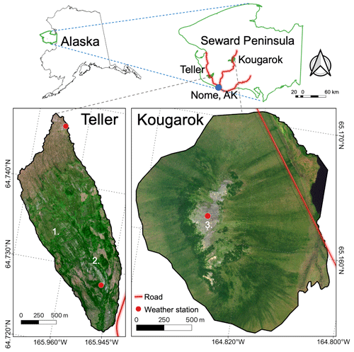
The spatial distribution of snow plays a vital role in sub-Arctic and Arctic climate, hydrology, and ecology due to its fundamental influence on the water balance, thermal regimes, vegetation, and carbon flux. However, the spatial distribution of snow is not well understood, and therefore, it is not well modeled, which can lead to substantial uncertainties in snow cover representations. To capture key hydro-ecological controls on snow spatial distribution, we carried out intensive field studies over multiple years for two small (2017–2019; ∼ 2.5 km2) sub-Arctic study sites located on the Seward Peninsula of Alaska. Using an intensive suite of field observations (> 22 000 data points), we developed simple models of the spatial distribution of snow water equivalent (SWE) using factors such as topographic characteristics, vegetation characteristics based on greenness (normalized different vegetation index, NDVI), and a simple metric for approximating winds. The most successful model was random forest, using both study sites and all years, which was able to accurately capture the complexity and variability of snow characteristics across the sites. Approximately 86 % of the SWE distribution could be accounted for, on average, by the random forest model at the study sites. Factors that impacted year-to-year snow distribution included NDVI, elevation, and a metric to represent coarse microtopography (topographic position index, TPI), while slope, wind, and fine microtopography factors were less important. The characterization of the SWE spatial distribution patterns will be used to validate and improve snow distribution modeling in the Department of Energy’s Earth system model and for improved understanding of hydrology, topography, and vegetation dynamics in the sub-Arctic and Arctic regions of the globe.


