
2025-04-24 デラウェア大学(UD)
")
Many farms in the Delmarva are seeing a reduction in crop health or bare patches on farmlands where nothing grows due to rising salinity in their soils.
<関連情報>
- https://www.udel.edu/udaily/2025/april/delmarva-salt-water-intrusion-salt-patches-farm-farmland-crops-agriculture-marsh/
- https://www.sciencedirect.com/science/article/abs/pii/S003442572500046X
- https://www.nature.com/articles/s41893-023-01186-6
急速に塩類化する沿岸景観をモニタリングするための非線形スペクトル混合除去法 Non-linear spectral unmixing for monitoring rapidly salinizing coastal landscapes
Manan Sarupria, Rodrigo Vargas, Matthew Walter, Jarrod Miller, Pinki Mondal
Remote Sensing of Environment Available online: 7 February 2025
DOI:https://doi.org/10.1016/j.rse.2025.114642
Highlights
- A new method for performing non-linear spectral unmixing using Sentinel-2.
- Sub-pixel estimates indicate 3-fold increase in salt patch extent since 2017.
- Uncertainty estimates from Random Forest model outputs indicate robustness.
- Model’s sensitivity to varying input data amounts was assessed.
- This method can be extended to other regions with proper input data.
Abstract
Coastal farmlands in the eastern United States of America (USA) are increasingly suffering from rising soil salinity, rendering them unsuitable for economically productive agriculture. Saltwater intrusion (SWI) into the groundwater reservoir or soil salinization can result in land cover modification (e.g. reduced plant growth) or land cover conversion. Two primary examples of such land cover conversion are farmland to marsh or farmland to salt patches with no vegetation growth. However, due to varying spatial granularity of these conversions, it is challenging to quantify these land covers over a large geographic scale. To address this challenge, we evaluated a non-linear spectral unmixing approach with a Random Forest (RF) algorithm to quantify fractional abundance of salt patch and marshes. Using Sentinel-2 imagery from 2022, we generated gridded datasets for salt patches and marshes across the Delmarva Peninsula, and the associated uncertainty. Moreover, we developed two new spectral indices to enhance the spectral unmixing accuracy: the Normalized Difference Salt Patch Index (NDSPI) and the Modified Salt Patch Index (MSPI). We constructed two sets of ten RF models: one for salt patches and the other for marshes, achieving high (>99 %) training and testing accuracies for classification. The consistently high accuracy and low error values across different model runs demonstrate the method’s reliability for classifying spectrally similar land cover classes in the mid-Atlantic region and beyond. Validation metrics for sub-pixel fractional abundances in the salt model revealed a moderate R-squared value of 0.50, and a high R-squared value of 0.90 for the marsh model. Our method complements labor-intensive field-based salinity measurements by offering a reproducible method that can be repeated annually and scaled up to cover large geographic regions.
米国中部大西洋岸における塩水楔の広がりとコスト The spread and cost of saltwater intrusion in the US Mid-Atlantic
Pinki Mondal,Matthew Walter,Jarrod Miller,Rebecca Epanchin-Niell,Keryn Gedan,Vishruta Yawatkar,Elizabeth Nguyen & Katherine L. Tully
Nature Sustainability Published:20 July 2023
DOI:https://doi.org/10.1038/s41893-023-01186-6
Abstract
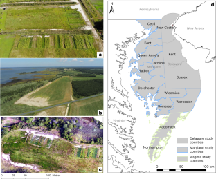
Saltwater intrusion on coastal farmlands can render productive land unsuitable for agricultural activities. While the visible extent of salt-impacted land provides a useful saltwater intrusion proxy, it is challenging to identify in early stages. Moreover, associated ecological and economic impacts are often underestimated as reduced crop yields in farmlands surrounding salt patches are difficult to quantify. Here we develop a high-resolution (1 m) dataset showing salt patches on farm fringes and quantify the extent of salt-impacted lands across the Delmarva Peninsula, United States. Our method is transferable to other regions across and beyond the mid-Atlantic with similar saltwater intrusion issues, such as Georgia and the Carolinas. Our results show that between 2011 and 2017, visible salt patches almost doubled and 8,096 ha of farmlands converted to marsh—another saltwater intrusion consequence. Field-based electrical conductivity measurements show elevated salinity values hundreds of metres from visible salt patches, indicating the broader extent of at-risk farmlands. More farmland areas were within 200 m of a visible salt patch in 2017 compared to 2011, a rise ranging between 68% in Delaware and 93% in Maryland. On the basis of assumed 100% profit loss in at-risk farmlands within a 200 m buffer around salt patches in 2016–2017, the range of economic losses was estimated between US$39.4 million and US$107.5 million annually, under 100% soy or corn counterfactuals, respectively.

")
")