2024-10-10 NASA

<関連情報>
The imaging spectrometer aboard the Carbon Mapper Coalition’s Tanager-1 satellite identified methane and carbon dioxide plumes in the United States and internationally.
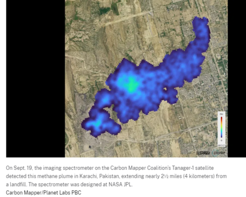
Using data from an instrument designed by NASA’s Jet Propulsion Laboratory in Southern California, the nonprofit Carbon Mapper has released the first methane and carbon dioxide detections from the Tanager-1 satellite. The detections highlight methane plumes in Pakistan and Texas, as well as a carbon dioxide plume in South Africa.
The data contributes to Carbon Mapper’s goal to identify and measure greenhouse gas point-source emissions on a global scale and make that information accessible and actionable.
Enabled by Carbon Mapper and built by Planet Labs PBC, Tanager-1 launched from Vandenberg Space Force Base in California on Aug. 16 and has been collecting data to verify that its imaging spectrometer, which is based on technology developed at NASA JPL, is functioning properly. Both Planet Labs PBC and JPL are members of the philanthropically funded Carbon Mapper Coalition.
“The first greenhouse gas images from Tanager-1 are exciting and are a compelling sign of things to come,” said James Graf, director for Earth Science and Technology at JPL. “The satellite plays a crucial role in detecting and measuring methane and carbon dioxide emissions. The mission is a giant step forward in addressing greenhouse gas emissions.”
The data used to produce the Pakistan image was collected over the city of Karachi on Sept. 19 and shows a roughly 2.5-mile-long (4-kilometer-long) methane plume emanating from a landfill. Carbon Mapper’s preliminary estimate of the source emissions rate is more than 2,600 pounds (1,200 kilograms) of methane released per hour.
The image collected that same day over Kendal, South Africa, displays a nearly 2-mile-long (3-kilometer-long) carbon dioxide plume coming from a coal-fired power plant. Carbon Mapper’s preliminary estimate of the source emissions rate is roughly 1.3 million pounds (600,000 kilograms) of carbon dioxide per hour.
The Texas image, collected on Sept. 24, reveals a methane plume to the south of the city of Midland, in the Permian Basin, one of the largest oilfields in the world. Carbon Mapper’s preliminary estimate of the source emissions rate is nearly 900 pounds (400 kilograms) of methane per hour.
In the 1980s, JPL helped pioneer the development of imaging spectrometers with AVIRIS (Airborne Visible/Infrared Imaging Spectrometer), and in 2022, NASA installed the imaging spectrometer EMIT (Earth Surface Mineral Dust Source Investigation), developed at JPL, aboard the International Space Station.
A descendant of those instruments, the imaging spectrometer aboard Tanager-1 can measure hundreds of wavelengths of light reflected from Earth’s surface. Each chemical compound on the ground and in the atmosphere reflects and absorbs different combinations of wavelengths, which give it a “spectral fingerprint” that researchers can identify. Using this approach, Tanager-1 will help researchers detect and measure emissions down to the facility level.
Once in full operation, the spacecraft will scan about 116,000 square miles (300,000 square kilometers) of Earth’s surface per day. Methane and carbon dioxide measurements collected by Tanager-1 will be publicly available on the Carbon Mapper data portal.


