2024-01-30 バッファロー大学(UB)
◆研究によれば、グリーンランドと南極は2003年から2019年までに年間で合計320ギガトンの質量を失い、北極では冬の海氷が30%減少。未来の変化を検出するためにはより長期のデータが必要であり、アメリカにはICESat-2とGEDIの後に新たなレーザーアルチメトリーミッションが予定されていない。次の10年サーベイが2027年に行われ、宇宙ミッションと研究の方向性に影響を与える見込み。
<関連情報>
- https://www.buffalo.edu/news/releases/2024/01/space-lasers-have-unearthed-plethora-of-climate-data-over-the-years.html
- https://www.nature.com/articles/s43017-023-00508-8
衛星レーザー高度測定による地球の気候変動モニタリング Monitoring Earth’s climate variables with satellite laser altimetry
Lori A. Magruder,Sinead L. Farrell,Amy Neuenschwander,Laura Duncanson,Beata Csatho,Sahra Kacimi & Helen A. Fricker
Nature Reviews Earth & Environment Published:30 January 2024
DOI:https://doi.org/10.1038/s43017-023-00508-8

Abstract
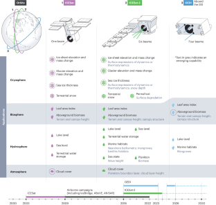
Satellite laser altimetry measures accurate elevations of the Earth’s surface and precise changes with time, monitoring key climate variables. These observations have transformed understanding of the Earth System, revealing changes and dynamics across spheres. In this Review, we highlight the Earth and climate science contributions from three NASA satellite laser altimeter missions: Ice, Cloud and land Elevation Satellite (ICESat; 2003–2009), ICESat-2 (2018 to present) and Global Ecosystem Dynamics Investigation (GEDI; 2018 to present). Over two decades of observations, satellite altimetry revealed cryosphere decline, including a loss of 320 Gt yr−1 in global land ice from Greenland and Antarctica, and a 30% decrease in volume of winter sea ice in the Arctic between 2003 and 2021. Observations have also been key to understanding ecosystems on land, providing data on the hydrosphere (showing that 57% of the Earth’s seasonal terrestrial water storage variability comes from human-managed reservoirs) and biosphere (showing that forest carbon stocks have globally increased owing to growth, despite a loss of the equivalent of ~8 Gt CO2 from land use). In the atmosphere, the data have enabled assessment of the global vertical cloud distribution, aerosol fraction, and dust and smoke transport. There is currently no planned satellite laser altimeter mission to continue from ICESat-2 and GEDI, jeopardizing critical data collection that supports decision-making and environmental management.
Key points
- NASA’s three satellite laser altimeter missions (ICESat, GEDI and ICESat-2) have provided surface elevation data for monitoring essential climate variables across the Earth system, at high spatial and temporal resolution.
- In the cryosphere, ICESat and ICESat-2 observations revealed a decline in sea ice thickness in the Arctic and a loss of land ice from glaciers, the Greenland Ice Sheet and the Antarctic Ice Sheet, and provided insights into the drivers of loss.
- In the biosphere, ICESat, ICESat-2 and GEDI measured vegetation structure and ground heights across all ecosystems to better quantify changes to the biosphere in response to climatic and anthropogenic forces.
- In the hydrosphere, ICESat, ICESat-2 and GEDI inventoried and monitored global water reservoirs and sea level changes including in the Arctic Ocean. ICESat-2 provides nearshore bathymetry for benthic mapping and coastal geomorphology.
- In the atmosphere, ICESat and ICESat-2 have provided vertical structure of global clouds and aerosol layers critical to modelling radiative fluxes. They have also revealed substantial climate events associated with dust storms and fire disturbances.


