2024-10-31 ノースカロライナ州立大学(NCState)
<関連情報>
- https://news.ncsu.edu/2024/10/satellite-imagery-may-help-protect-coastal-forests-from-climate-change/
- https://link.springer.com/article/10.1007/s10021-024-00938-5
リモートセンシングによる沿岸湿地帯のレジームシフトと回復力の喪失の軌跡の検出 Detecting Trajectories of Regime Shifts and Loss of Resilience in Coastal Wetlands using Remote Sensing
Melinda Martinez,Marcelo Ardón & Josh Gray
Ecosystems Published:31 October 2024
DOI:https://doi.org/10.1007/s10021-024-00938-5

Abstract
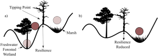
Many freshwater forested wetlands along the southeastern United States coastline are rapidly transitioning from forest to marsh or open water, due to climate change-related disturbances. Recent studies have found early warning signals (EWS) of regime shifts in other ecosystems, but it is unclear if these can be detected for coastal wetlands. In this study, we examined the ability to detect EWS of regime shifts in coastal wetlands within the Albemarle Pamlico peninsula (APP), North Carolina, U.S.A. We used the Landsat record (1985–2021) to examine trends of normalized difference vegetation index (NDVI) time series for selected areas known to have undergone regime shifts. We found that while 77% of the APP was either stable or revegetating, 22% of the landscape underwent a decrease in NDVI that would indicate a transition from forest to marsh or open water. Of the areas that transitioned, about half (11%) experienced an abrupt decrease in NDVI and 10% experienced a gradual decline. Increasing standard deviation and skewness of time series could serve as EWS of abrupt transitions, but can also provide false negative and positives. Our results suggest that ecosystem transitions from a forest to a marsh or open water can occur both rapidly and slowly, and remote sensing of NDVI time series can help identify EWS for some areas, but not all. Our results allow for prioritization of conservation/restoration of coastlines which will become important in the face of climate change and sea level rise.


