2025-04-29 東京大学

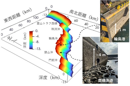
2024年能登半島地震を発生させた活断層の「かたち」と各地での隆起量の違い
<関連情報>
- https://www.s.u-tokyo.ac.jp/ja/press/10748/
- https://earth-planets-space.springeropen.com/articles/10.1186/s40623-025-02187-9
Mw7.5の能登半島地震から得られた証拠:非平面3次元断層形状はすべりおよび隆起の時空間分布を制御する Nonplanar 3D fault geometry controls the spatiotemporal distributions of slip and uplift: evidence from the Mw 7.5 2024 Noto Peninsula, Japan, Earthquake
Ryosuke Ando,Yo Fukushima,Keisuke Yoshida & Kazutoshi Imanishi
Earth, Planets and Space Published:29 April 2025
DOI:https://doi.org/10.1186/s40623-025-02187-9
Abstract
The 2024 Mw 7.5 Noto Peninsula Earthquake broke through a previously documented active fault system over 150 km in the northern central Japanese Island. This fault system is characterized by geometrical complexity. It is important to understand the physical mechanism underlying the multi-fault rupture. We conduct fully dynamic rupture simulations and identify that the 3D fault geometry controls the observed rupture process and heterogeneous spatiotemporal patterns of the fault slip, seismic radiation and crustal deformation exhibiting about five meters of the maximum uplift. Aiming to examine the effect of the 3D fault geometry, we exclude the heterogeneity arising from the frictional properties. We also avoid retrospective frictional parameter tunings to fit the coseismic observations to test whether it is possible for our forward modeling to reproduce the coseismic observations. The 3D nonplanar geometry model is built based on the previously documented surface fault traces, and we use the regional stress field determined by the stress tensor inversion. As a result, the dynamic rupture simulation reasonably reproduces the observed characteristics of the heterogeneous deformation patterns. We find the rupture is accelerated, and slip is increased, where the fault is bent and optimally oriented to the regional stress orientations. Remarkably, the spatial distribution of surface displacement captured by the Synthetic Aperture Radar imageries is quantitatively reproduced, as characterized by two areas of large and small peaks of uplifts. Our findings may contribute to better constraining future earthquake rupture scenarios.


