2024-06-24 パシフィック・ノースウェスト国立研究所(PNNL)
<関連情報>
- https://www.pnnl.gov/publications/high-resolution-land-surface-dataset-provides-earth-system-modeling-details
- https://essd.copernicus.org/articles/16/2007/2024/
キロメートル規模の地球システムモデリングのための全球1km地表面パラメータ Global 1 km land surface parameters for kilometer-scale Earth system modeling
Lingcheng Li, Gautam Bisht, Dalei Hao, and L. Ruby Leung
Earth System Science Data Published: 29 Apr 2024
DOI:https://doi.org/10.5194/essd-16-2007-2024

Abstract
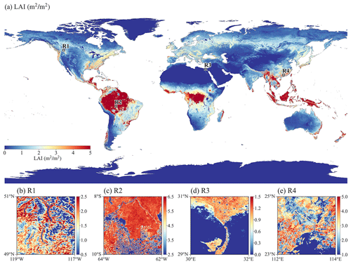
Earth system models (ESMs) are progressively advancing towards the kilometer scale (“k-scale”). However, the surface parameters for land surface models (LSMs) within ESMs running at the k-scale are typically derived from coarse-resolution and outdated datasets. This study aims to develop a new set of global land surface parameters with a resolution of 1 km for multiple years from 2001 to 2020, utilizing the latest and most accurate available datasets. Specifically, the datasets consist of parameters related to land use and land cover, vegetation, soil, and topography. Differences between the newly developed 1 km land surface parameters and conventional parameters emphasize their potential for higher accuracy due to the incorporation of the most advanced and latest data sources. To demonstrate the capability of these new parameters, we conducted 1 km resolution simulations using the E3SM Land Model version 2 (ELM2) over the contiguous United States. Our results demonstrate that land surface parameters contribute to significant spatial heterogeneity in ELM2 simulations of soil moisture, latent heat, emitted longwave radiation, and absorbed shortwave radiation. On average, about 31 % to 54 % of spatial information is lost by upscaling the 1 km ELM2 simulations to a 12 km resolution. Using eXplainable Machine Learning (XML) methods, the influential factors driving the spatial variability and spatial information loss of ELM2 simulations were identified, highlighting the substantial impact of the spatial variability and information loss of various land surface parameters, as well as the mean climate conditions. The comparison against four benchmark datasets indicates that ELM generally performs well in simulating soil moisture and surface energy fluxes. The new land surface parameters are tailored to meet the emerging needs of k-scale LSM and ESM modeling with significant implications for advancing our understanding of water, carbon, and energy cycles under global change. The 1 km land surface parameters are publicly available at https://doi.org/10.5281/zenodo.10815170 (Li et al., 2024).


