
2025-01-17 マックス・プランク研究所
<関連情報>
- https://www.mpg.de/23899031/permafrost-climate-change?c=2249
- https://agupubs.onlinelibrary.wiley.com/doi/10.1029/2024GL109034
- https://www.nature.com/articles/s41558-023-01715-3
- https://www.nature.com/articles/s41558-024-02074-3
- https://www.nature.com/articles/s41558-022-01281-0
- https://bg.copernicus.org/articles/20/2837/2023/
- https://iopscience.iop.org/article/10.1088/1748-9326/ad6019
永久凍土の雲のフィードバックが気候変動を増幅する可能性 Permafrost Cloud Feedback May Amplify Climate Change
Philipp de Vrese, Tobias Stacke, Veronika Gayler, Victor Brovkin
Geophysical Research Letters Published: 14 June 2024
DOI:https://doi.org/10.1029/2024GL109034
")
Abstract
Rising temperatures entail important changes in the soil hydrologic processes of the northern permafrost zone. Using the ICON-Earth System Model, we show that a large-scale thaw of essentially impervious frozen soil layers may cause a positive feedback by which permafrost degradation amplifies the causative warming. The thawing of the ground increases its hydraulic connectivity and raises drainage rates which facilitates a drying of the landscapes. This limits evapotranspiration and the formation of low-altitude clouds during the snow-free season. A decrease in summertime cloudiness, in turn, increases the shortwave radiation reaching the surface, hence, temperatures and advances the permafrost degradation. Our simulations further suggest that the consequences of a permafrost cloud feedback may not be limited to the regional scale. For a near-complete loss of the high-latitude permafrost, they show significant temperature impacts on all continents and northern-hemisphere ocean basins that raise the global mean temperature by 0.25 K.
Key Points
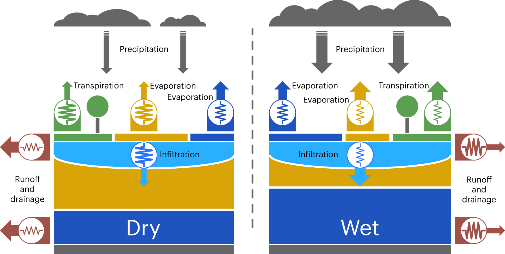
- Advanced degradation of permafrost may facilitate large-scale landscape drying
- Dependency of clouds on terrestrial hydrology allows for feedback between permafrost thaw, diminished cloudiness and rising temperatures
- This feedback could amplify global warming notably
Plain Language Summary
Landscapes in the Arctic and subarctic zone are often very wet with highly water saturated soils and an extensive lake- and wetland cover. To some extent, this is due to the perennially frozen soil layers that underlay large parts of these regions and inhibit the movement of water through the ground. Thus, a thawing of the frozen soils, caused by rising temperatures, may ultimately lead to a drying of the landscapes. Here, we use simulations with the ICON-Earth System Model to show that such a drying increases regional temperatures via an atmospheric feedback: During the warm season, dryer conditions at the surface reduce the moisture transport into the atmosphere. This decreases the relative humidity in the boundary layer and the low-altitude cloud cover. Since clouds reflect more sunlight than the snow-free land surface, the reduced cloudiness increases the available energy, hence, temperatures and advances the thawing of the ground. Higher temperatures in the Arctic and subarctic zone, in turn, have important consequences for the net energy exchange between equatorial and polar regions. Thus, the effects of a large-scale drying of high-latitude soils may not be limited to the regional scale but could notably increase global mean temperatures.
北極圏のCH4排出量の湿潤度に対する感度は、大気のフィードバックによって低下する Sensitivity of Arctic CH4 emissions to landscape wetness diminished by atmospheric feedbacks
Philipp de Vrese,Lutz Beckebanze,Leonardo de Aro Galera,David Holl,Thomas Kleinen,Lars Kutzbach,Zoé Rehder & Victor Brovkin
Nature Climate Change Published:06 July 2023
DOI:https://doi.org/10.1038/s41558-023-01715-3
Abstract
Simulations using land surface models suggest future increases in Arctic methane emissions to be limited by the thaw-induced drying of permafrost landscapes. Here we use the Max Planck Institute Earth System Model to show that this constraint may be weaker than previously thought owing to compensatory atmospheric feedbacks. In two sets of extreme scenario simulations, a modification of the permafrost hydrology resulted in diverging hydroclimatic trajectories that, however, led to comparable methane fluxes. While a wet Arctic showed almost twice the wetland area compared with an increasingly dry Arctic, the latter featured greater substrate availability due to higher temperatures resulting from reduced evaporation, diminished cloudiness and more surface solar radiation. Given the limitations of present-day models and the potential model dependence of the atmospheric response, our results provide merely a qualitative estimation of these effects, but they suggest that atmospheric feedbacks play an important role in shaping future Arctic methane emissions.
沿岸永久凍土の侵食による北極海のCO2吸収量の減少 Reduced Arctic Ocean CO2 uptake due to coastal permafrost erosion
David M. Nielsen,Fatemeh Chegini,Joeran Maerz,Sebastian Brune,Moritz Mathis,Mikhail Dobrynin,Johanna Baehr,Victor Brovkin & Tatiana Ilyina
Nature Climate Change Published:12 August 2024
DOI:https://doi.org/10.1038/s41558-024-02074-3
An Addendum to this article was published on 27 August 2024
Abstract
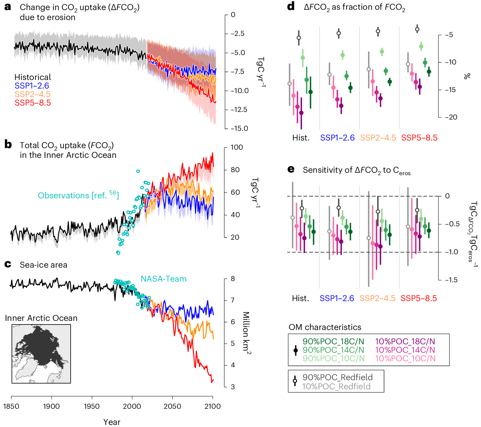
Arctic coastal permafrost erosion is projected to increase by a factor of 2–3 by 2100. However, organic matter fluxes from the coastal permafrost into the ocean have not been considered in Earth system models so far. Here we represent coastal permafrost erosion in an Earth system model and perform simulations with varying permafrost organic matter properties, such as sinking fraction and nutrient content. We find that coastal erosion reduces the Arctic Ocean CO2 uptake from the atmosphere in all simulations: by 4.6–13.2 TgC yr−1 by 2100, which is ~7–14% of the Inner Arctic Ocean uptake. We show that coastal permafrost erosion exerts a positive biogeochemical feedback on climate, increasing atmospheric CO2 by 1–2 TgC yr−1 per °C of increase in global surface air temperature. Our work will allow coastal permafrost erosion to be considered in future climate change assessments.
21世紀における北極海の海岸侵食の増加と温暖化に対するその感度 Increase in Arctic coastal erosion and its sensitivity to warming in the twenty-first century
David Marcolino Nielsen,Patrick Pieper,Armineh Barkhordarian,Paul Overduin,Tatiana Ilyina,Victor Brovkin,Johanna Baehr & Mikhail Dobrynin
Nature Climate Change Published:14 February 2022
DOI:https://doi.org/10.1038/s41558-022-01281-0
Abstract
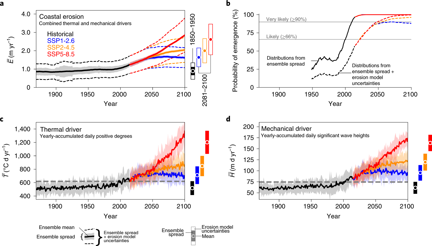
Arctic coastal erosion damages infrastructure, threatens coastal communities and releases organic carbon from permafrost. However, the magnitude, timing and sensitivity of coastal erosion increase to global warming remain unknown. Here we project the Arctic-mean erosion rate to increase and very likely exceed its historical range of variability before the end of the century in a wide range of emission scenarios. The sensitivity of erosion to warming roughly doubles, reaching 0.4–0.8 m yr−1 °C−1 and 2.3–4.2 TgC yr−1 °C−1 by the end of the century. We develop a simplified semi-empirical model to produce twenty-first-century pan-Arctic coastal erosion rate projections. Our results will inform policymakers on coastal conservation and socioeconomic planning, and organic carbon flux projections lay out the path for future work to investigate the impact of Arctic coastal erosion on the changing Arctic Ocean, its role as a global carbon sink, and the permafrost–carbon feedback.
北極圏の池からのメタン排出量は温暖化に非常に敏感である Simulated methane emissions from Arctic ponds are highly sensitive to warming
Zoé Rehder, Thomas Kleinen, Lars Kutzbach, Victor Stepanenko, Moritz Langer, and Victor Brovkin
Biogeosciences Published:17 Jul 2023
DOI:https://doi.org/10.5194/bg-20-2837-2023
Abstract
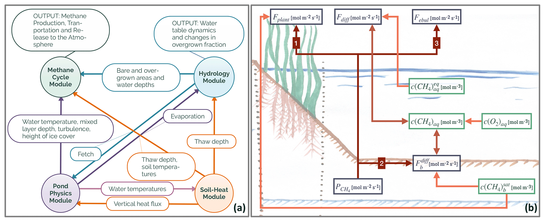
The Arctic is warming at an above-average rate, and small, shallow waterbodies such as ponds are vulnerable to this warming due to their low thermal inertia compared to larger lakes. While ponds are a relevant landscape-scale source of methane under the current climate, the response of pond methane emissions to warming is uncertain. We employ a new, process-based model for methane emissions from ponds (MeEP) to investigate the methane emission response of polygonal-tundra ponds in northeastern Siberia to warming.
MeEP is the first dedicated model of pond methane emissions which differentiates between the three main pond types of the polygonal-tundra, ice-wedge, polygonal-center, and merged polygonal ponds and resolves the three main pathways of methane emissions – diffusion, ebullition, and plant-mediated transport. We perform idealized warming experiments, with increases in the mean annual temperature of 2.5, 5, and 7.5 ∘C on top of a historical simulation. The simulations reveal an approximately linear increase in emissions from ponds of 1.33 g CH4 yr−1 ∘C−1 m−2 in this temperature range. Under annual temperatures 5 ∘C above present temperatures, pond methane emissions are more than 3 times higher than now. Most of this emission increase is due to the additional substrate provided by the increased net productivity of the vascular plants. Furthermore, plant-mediated transport is the dominating pathway of methane emissions in all simulations. We conclude that vascular plants as a substrate source and efficient methane pathway should be included in future pan-Arctic assessments of pond methane emissions.
地表面モデルの解像度が北極圏のフラックスと土壌状態に及ぼす影響 Effects of land surface model resolution on fluxes and soil state in the Arctic
Meike Schickhoff, Philipp de Vrese, Annett Bartsch, Barbara Widhalm and Victor Brovkin
Environmental Research Letters Published: 30 August 2024
DOI:10.1088/1748-9326/ad6019

Abstract
Arctic land is characterized by a high surface and subsurface heterogeneity on different scales. However, the effects of land surface model resolution on fluxes and soil state variables in the Arctic have never been systematically studied, even though smaller scale heterogeneities are resolved in high-resolution land boundary condition datasets. Here, we compare 210 km and 5 km setups of the land surface model JSBACH3 for an idealized case study in eastern Siberia to investigate the effects of high versus low-resolution land boundary conditions on simulating the interactions of soil physics, hydrology and vegetation. We show for the first time that there are differences in the spatial averages of the simulated fluxes and soil state variables between resolution setups. Most differences are small in the summer mean, but larger within individual months. Heterogeneous soil properties induce large parts of the differences while vegetation characteristics play a minor role. Active layer depth shows a statistically significant increase of +20% in the 5 km setup relative to the 210 km setup for the summer mean and +43% for August. The differences are due to the nonlinear vertical discretization of the soil column amplifying the impact of the heterogeneous distributions of soil organic matter content and supercooled water. Resolution-induced differences in evaporation fluxes amount to +43% in July and are statistically significant. Our results show that spatial resolution significantly affects model outcomes due to nonlinear processes in heterogenous land surfaces. This suggests that resolution needs to be accounted in simulations of land surface models in the Arctic.

")
")