2026-01-19 東北大学

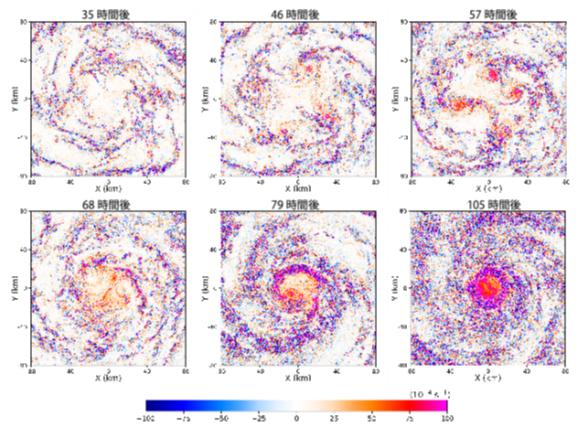
図1. 地表面付近の鉛直渦度(値の大きさが回転の強さ、符号の正が反時計回り、負が時計回りに対応)の台風の発達期から成熟期までの時間発展
<関連情報>
- https://www.tohoku.ac.jp/japanese/2026/01/press20260119-02-fugaku.html
- https://www.tohoku.ac.jp/japanese/newimg/pressimg/tohokuuniv-press20260119_02web_fugaku.pdf
- https://agupubs.onlinelibrary.wiley.com/doi/10.1029/2025GL119560
初期渦から成熟までの熱帯低気圧全体のラージエディシミュレーション Large Eddy Simulation of an Entire Tropical Cyclone From Initial Vortex to Maturity
J. Ito, Y. Sakurai, L. P. S. Tonga, H. Niino, Y. Miyamoto
Geophysical Research Letters Published: 14 January 2026
DOI:https://doi.org/10.1029/2025GL119560
Abstract
We simulated a tropical cyclone in an idealized environment, from its weak initial vortex to maturity, using a regional numerical weather prediction model with a uniform horizontal resolution of 100 m, regarded as a large eddy simulation (LES). Results of the LES were compared with those of the same model, but with a horizontal resolution of 2 km. Both experiments attained similar peak intensities (<?XML:NAMESPACE PREFIX = “[default] http://www.w3.org/1998/Math/MathML” NS = “http://www.w3.org/1998/Math/MathML” /> hPa), but the LES uniquely captured kilometer-scale rolls in the boundary layer, persistent shallow mesovortices near the eyewall, and countless sub-kilometer-scale patches of positive and negative vorticity. Rapid intensification (RI) in the LES was delayed by approximately 26 hr relative to that in the 2 km model. Composite analysis confirmed that mesovortices interfered with the azimuthally averaged secondary circulation. The prevalence of negative vorticity and decelerated inflow in the LES are likely to delay the RI.
Plain Language Summary
Predicting changes in tropical cyclone (TC) intensity, especially the timing of rapid intensification (RI), remains a major challenge. We used a very high-resolution model with 100-m grid spacing that explicitly simulates atmospheric turbulence. This is the first simulation of an entire TC, from an initial vortex to maturity, at such fine resolution. For comparison, we also ran a commonly-used 2-km resolution simulation. While both simulations reached similar peak intensities, only the high-resolution run captured detailed boundary layer turbulence, longer-lived eyewall mesovortices, and numerous small-scale counter-rotating vortices. These features disrupted the inflow and delayed RI by about one day.
Key Points
- This is the first large eddy simulation (LES) that captured the full development of an entire tropical cyclone
- Rapid intensification in LES starts 26 hr later than coarse resolution model, possibly due to existence of long-lived mesovortices
- In LES, positive and negative vertical vorticity are much stronger, while net updraft is weaker


