
2024-10-21 コロンビア大学
<関連情報>
- https://news.climate.columbia.edu/2024/10/21/shaking-from-aprils-new-jersey-quake-went-oddly-far-raising-questions-on-regional-hazard/
- https://pubs.geoscienceworld.org/ssa/tsr/article/4/4/240/648801/Preliminary-Observations-of-the-5-April-2024-Mw-4
- https://pubs.geoscienceworld.org/ssa/tsr/article/4/3/214/648491/Rupture-Model-of-the-5-April-2024-Tewksbury-New
- https://pubs.geoscienceworld.org/ssa/bssa/article-abstract/98/4/1696/350118/Observations-and-Tectonic-Setting-of-Historic-and
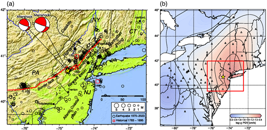
2024年4月5日の予備的観測 4.8ニュージャージー地震 Preliminary Observations of the 5 April 2024 Mw 4.8 New Jersey Earthquake
Oliver S. Boyd;William D. Barnhart;James Bourke;Martin Chapman;Paul S. Earle;Guo‐chin Dino Huang;Jessica A. Thompson Jobe;Won‐Young Kim;Frederik Link;Mairi Litherland;Andrew Lloyd;Maureen D. Long;Sara McBride;Andrew J. Michael;Walter D. Mooney;Gregory S. Mountain;Sissy Nikolaou;Alexandros Savvaidis;Felix Waldhauser;Cecily J. Wolfe;Clara Yoon
The Seismic Record Published:October 01, 2024
DOI:https://doi.org/10.1785/0320240024
")
Abstract
On 5 April 2024, 10:23 a.m. local time, a moment magnitude 4.8 earthquake struck Tewksbury Township, New Jersey, about 65 km west of New York City. Millions of people from Virginia to Maine and beyond felt the ground shaking, resulting in the largest number (>180,000) of U.S. Geological Survey (USGS) “Did You Feel It?” reports of any earthquake. A team deployed by the Geotechnical Extreme Events Reconnaissance Association and the National Institute of Standards and Technology documented structural and nonstructural damage, including substantial damage to a historic masonry building in Lebanon, New Jersey. The USGS National Earthquake Information Center reported a focal depth of about 5 km, consistent with a lack of signal in Interferometric Synthetic Aperture Radar data. The focal mechanism solution is strike slip with a substantial thrust component. Neither mechanism’s nodal plane is parallel to the primary northeast trend of geologic discontinuities and mapped faults in the region, including the Ramapo fault. However, many of the relocated aftershocks, for which locations were augmented by temporary seismic deployments, form a cluster that parallels the general northeast trend of the faults. The aftershocks lie near the Tewksbury fault, north of the Ramapo fault.
地域Lg波データに基づく2024年4月5日ニュージャージー州テュークスベリー地震の破壊モデル Rupture Model of the 5 April 2024 Tewksbury, New Jersey, Earthquake Based on Regional Lg‐Wave Data
Sangwoo Han;Won‐Young Kim;Jun Yong Park;Min‐Seong Seo;YoungHee Kim
The Seismic Record Published:September 18, 2024
DOI:https://doi.org/10.1785/0320240020
Abstract
On 5 April 2024, an earthquake of magnitude 4.8 occurred in Tewksbury, New Jersey. It was the largest instrumentally recorded event since 1900 in New Jersey and southern New York. Millions of people around New York City, ∼65 km east‐northeast of Tewksbury, felt the shaking from the mainshock, but the epicentral area experienced no known significant property damages. We determine the focal mechanism, which is oblique faulting, and retrieve the Lg‐wave relative source time functions (RSTFs) from the stations at regional distances to understand rupture processes and ground motions. Our fault‐slip models well explain azimuthal variations of the RSTFs. The models show the rupture propagating toward the east‐northeast (∼50° to 60°), not along the fault strike. The slip distribution on the nodal plane striking north and dipping to the east shows a slip area of 1.1 km radius with the rupture propagating down‐dip. The down‐dip rupture may account for the observed lack of strong shaking in the epicentral area.
グレーターニューヨークシティ-フィラデルフィア地域における歴史的地震と計器設置地震の観測と地殻変動設定 Observations and Tectonic Setting of Historic and Instrumentally Located Earthquakes in the Greater New York City–Philadelphia Area
Lynn R. Sykes;John G. Armbruster;Won-Young Kim;Leonardo Seeber
Bulletin of the Seismological Society of America Published:August 01, 2008
DOI:https://doi.org/10.1785/0120070167
Abstract
A catalog of 383 earthquakes in southeastern New York, southwestern Connecticut, northern New Jersey, and eastern Pennsylvania, including metropolitan New York City and Philadelphia, is compiled from historical and instrumental data from 1677 through 2006. A magnitude-felt area relationship is used to calculate the equivalent magnitude mbLg prior to the advent of abundant instrumental data in 1974. Revised locations are computed for a number of historic earthquakes. Most hypocenters are concentrated in older terranes bordering the Mesozoic Newark basin in the Reading, Manhattan, and Trenton prongs and in similar rocks found at a shallow depth beneath the coastal plain from south of New York City across central New Jersey. Historic shocks of mbLg 3 and larger were most numerous in the latter zone. The largest known event, mbLg 5.25, occurred just offshore of New York City in 1884. Many earthquakes have occurred beneath the 12-km wide Ramapo seismic zone (RSZ) in the eastern part of the Reading prong, where station coverage was the most extensive since 1974. The southeastern boundary of the RSZ, which is nearly vertical, extends from near the surface trace of the Mesozoic Ramapo fault to depths of 12–15 km. Because the Mesozoic border fault dips about 50°–60° southeast, earthquakes of the RSZ are occurring within middle Proterozoic through early Paleozoic rocks. Which faults within the RSZ are active is unclear. Well-located activity in the Manhattan prong since 1974 extends to similar depths but cuts off abruptly at all depths along a northwest-striking boundary extending from Peekskill, New York, to Stamford, Connecticut. That boundary, which is subparallel to brittle faults farther south, is inferred to be a similar fault or fault zone. Those brittle features may have formed between the Newark, Hartford, and New York bight basins to accommodate Mesozoic extension. The Great Valley in the northwestern part of the study region is nearly devoid of known earthquakes. While few focal mechanism solutions and in situ stress measurements of high quality are available, the maximum compressive stress is nearly horizontal and is oriented about N64°E, similar to that in adjacent areas. The catalog is likely complete for events of mbLg>5 since 1737, ≥3.5 since 1840, and ≥3.0 since 1928. Extrapolation of the frequency-magnitude relationship indicates that an event of mbLg≥6.0 is expected about once per 670 yr.


")