")
2024-09-24 NASA
<関連情報>
- https://www.nasa.gov/earth/arctic-sea-ice-near-historic-low-antarctic-ice-continues-decline/
- https://www.mdpi.com/2072-4292/16/16/2983
衛星高度計による北極海の海氷厚の20年間: 2003年から2023年までの海氷厚の変化と観測手法 Two Decades of Arctic Sea-Ice Thickness from Satellite Altimeters: Retrieval Approaches and Record of Changes (2003–2023)
Sahra Kacimi and Ron Kwok
Remote Sensing Published: 14 August 2024
DOI:https://doi.org/10.3390/rs16162983
Abstract
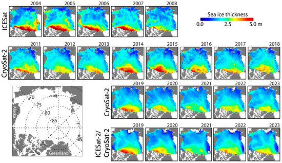
There now exists two decades of basin-wide coverage of Arctic sea ice from three dedicated polar-orbiting altimetry missions (ICESat, CryoSat-2, and ICESat-2) launched by NASA and ESA. Here, we review our retrieval approaches and discuss the composite record of Arctic ice thickness (2003–2023) after appending two more years (2022–2023) to our earlier records. The present availability of five years of snow depth estimates—from differencing lidar (ICESat-2) and radar (CryoSat-2) freeboards—have benefited from the concurrent operation of two altimetry missions. Broadly, the dramatic volume loss (5500 km3) and Arctic-wide thinning (0.6 m) captured by ICESat (2003–2009), primarily due to the decline in old ice coverage between 2003 and 2007, has slowed. In the central Arctic, away from the coasts, the CryoSat-2 and shorter ICESat-2 records show near-negligible thickness trends since 2007, where the winter and fall ice thicknesses now hover around 2 m and 1.3 m, from a peak of 3.6 m and 2.7 m in 1980. Ice volume production has doubled between the fall and winter with the faster-growing seasonal ice cover occupying more than half of the Arctic Ocean at the end of summer. Seasonal ice behavior dominates the Arctic Sea ice’s interannual thickness and volume signatures.

")
")