2025-06-30 ハーバード大学

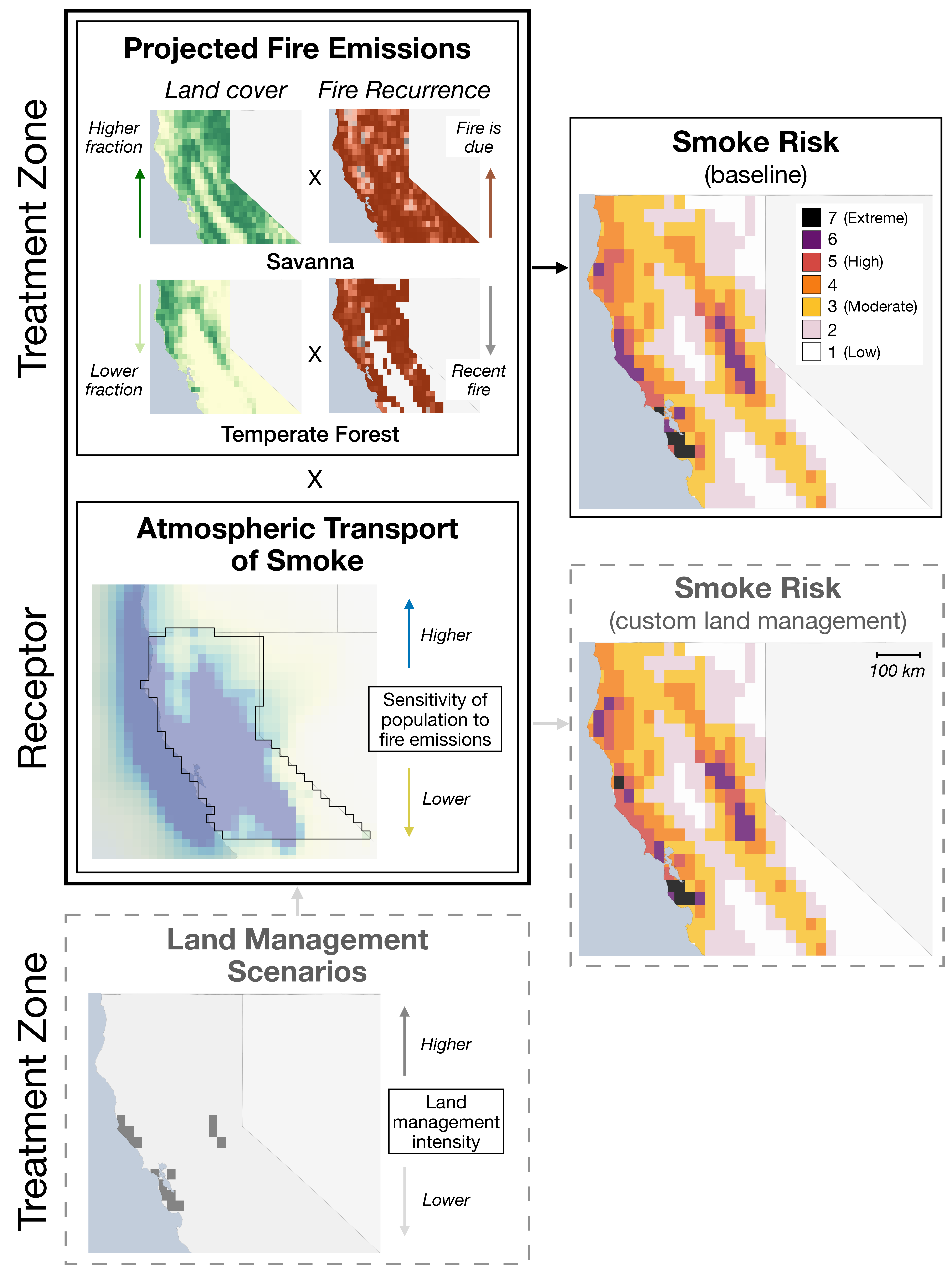
Schematic workflow for generating smoke risk index. The index is a metric that highlights those grid cells where potential wildfires would pose the greatest population-weighted smoke exposure downwind.
<関連情報>
- https://seas.harvard.edu/news/2025/06/where-theres-fire-theres-smoke
- https://smoke-policy-tool.projects.earthengine.app/view/smrt-flames
- https://pubs.acs.org/doi/10.1021/acs.est.5c01914
- https://agupubs.onlinelibrary.wiley.com/doi/10.1029/2022EF003468
山火事による煙リスクの管理: 北カリフォルニアを事例として Managing Smoke Risk from Wildland Fires: Northern California as a Case Study
Karina E. Chung,Tianjia Liu,Makoto M. Kelp,Karn Vohra,Dana Skelly,Matthew C. Carroll,Joel Schwartz,and Loretta J. Mickley
Environmental Science & Technology Published June 30, 2025
DOI:https://doi.org/10.1021/acs.est.5c01914
Abstract
Smoke fine particulate matter (PM2.5) from increasing wildfires in the western United States threatens public health. While land managers often prioritize reducing wildfire risk in the wildland-urban interface, the impact on regional air quality from mitigating wildfire spread has been less explored. We developed a framework to quantify wildfire contributions to smoke exposure and assess targeted land management strategies. This data-driven approach integrates fire emissions and smoke transport to generate a smoke risk index at 0.25° × 0.25° resolution. We deploy the smoke risk index in an online tool, enabling stakeholders to analyze smoke risk under various scenarios of burned area, fuel consumption, and land management. Using Northern California as a case study, we estimate that in 2020, targeted land management in the 15 highest risk areas (∼3.5% of the total) could have reduced smoke exposure by 17.6%. However, most prescribed burns conducted from 2017 to 2020 did not overlap with these high-risk zones. Our framework also estimates excess deaths from smoke PM2.5 exposure, attributing ∼36,400 (95% CI: 25,400–47,200) deaths nationally to western US fires in the year following the 2020 fire season. Our adaptable tool can incorporate higher-resolution data sets and help stakeholders prioritize fuel treatment and fire suppression to mitigate smoke exposure risks.
将来の山火事の煙暴露を軽減する手段としての計画的焼畑: 州および農村環境正義コミュニティのための教訓 Prescribed Burns as a Tool to Mitigate Future Wildfire Smoke Exposure: Lessons for States and Rural Environmental Justice Communities
Makoto M. Kelp, Matthew C. Carroll, Tianjia Liu, Robert M. Yantosca, Heath E. Hockenberry, Loretta J. Mickley
Earth’s Future Published: 14 June 2023
DOI:https://doi.org/10.1029/2022EF003468
Abstract
Smoke from wildfires presents one of the greatest threats to air quality, public health, and ecosystems in the United States, especially in the West. Here we quantify the efficacy of prescribed burning as an intervention for mitigating smoke exposure downwind of wildfires across the West during the 2018 and 2020 fire seasons. Using the adjoint of the GEOS-Chem chemical transport model, we calculate the sensitivities of population-weighted smoke concentrations in receptor regions, including states and rural environmental justice communities, to fire emissions upwind of the receptors. We find that the population-weighted smoke exposure across the West during the September 2020 fires was 44 μg/m3 but would have been 20%–30% greater had these wildfires occurred in October or November. We further simulate a set of prescribed burn scenarios and find that controlled burning interventions in northern California and the Pacific Northwest could have reduced the population-weighted smoke exposure across the western United States by 21 μg/m3 in September 2020, while doing so in all other states would have reduced smoke exposure by only 1.5 μg/m3. Satellite records of large, prescribed burns (>1,000 acres, or 4 km2) reveal that northern California and western Oregon conducted only seven such prescribed fires over a 6-year period (2015–2020), even though these regions have a disproportionate impact on smoke exposure for rural environmental justice communities and population centers across the West. Our analysis suggests that prioritizing northern California and the Pacific Northwest for prescribed burns might mitigate future smoke exposure.
Key Points
- The West Coast both experiences the largest smoke exposures and contributes most to the burden of smoke PM2.5 in the western US
- Applying prescribed burns on the coast yields large benefits for the West, while doing so in other states has relatively smaller impacts
- Larger prescribed burns may reduce smoke impacts from future large wildfires, but few such burns have occurred in key areas
Plain Language Summary
Catastrophic wildfires pose substantial risk to public health, infrastructures, and ecosystems in the western United States. As these large and costly wildfires become more common, methods to identify locations for prescribed burning are needed to mitigate impacts on affected populations and ecosystems. Here we investigate the effectiveness of prescribed burning for abating potential wildfire smoke exposures in states and rural environmental justice communities across the western United States during the destructive 2018 and 2020 fire seasons. We find that due in part to prevailing wind patterns, wildfires in the coastal states contribute more to overall smoke exposure in the West compared to wildfires in other states in both 2018 and 2020. We show that implementing prescribed burns in the heavily forested northern California and the Pacific Northwest would yield large net benefits for the entire western United States, while doing so in other states would have relatively smaller impacts. Our work suggests that land managers should prioritize northern California, western Oregon, and eastern Washington for prescribed burns to mitigate future smoke exposure as these regions have a disproportionate impact on smoke exposure for rural environmental justice communities and population centers across the West.


